
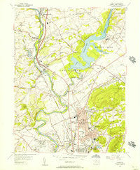
~ Temple PA topo map, 1:24000 scale, 7.5 X 7.5 Minute, Historical, 1956, updated 1957
Temple, Pennsylvania, USGS topographic map dated 1956.
Includes geographic coordinates (latitude and longitude). This topographic map is suitable for hiking, camping, and exploring, or framing it as a wall map.
Printed on-demand using high resolution imagery, on heavy weight and acid free paper, or alternatively on a variety of synthetic materials.
Topos available on paper, Waterproof, Poly, or Tyvek. Usually shipping rolled, unless combined with other folded maps in one order.
- Product Number: USGS-5328196
- Free digital map download (high-resolution, GeoPDF): Temple, Pennsylvania (file size: 11 MB)
- Map Size: please refer to the dimensions of the GeoPDF map above
- Weight (paper map): ca. 55 grams
- Map Type: POD USGS Topographic Map
- Map Series: HTMC
- Map Verison: Historical
- Cell ID: 44511
- Scan ID: 222134
- Imprint Year: 1957
- Woodland Tint: Yes
- Aerial Photo Year: 1947
- Field Check Year: 1956
- Datum: NAD27
- Map Projection: Polyconic
- Map published by United States Geological Survey
- Map Language: English
- Scanner Resolution: 600 dpi
- Map Cell Name: Temple
- Grid size: 7.5 X 7.5 Minute
- Date on map: 1956
- Map Scale: 1:24000
- Geographical region: Pennsylvania, United States
Neighboring Maps:
All neighboring USGS topo maps are available for sale online at a variety of scales.
Spatial coverage:
Topo map Temple, Pennsylvania, covers the geographical area associated the following places:
- Frush Valley - Rickenbach - Hyde Villa - Kindts Corner - Heather Knoll - Blandon - Urban Acres Trailer Park - Clearview Heights - Mohrsville - Shadow Ridge - Maiden Creek Estates - Laurel Commons Mobile Home Park - Berkley - Fox Chase - Temple - Ontelaunee - Leinbachs - Muhlenberg - Schlemville - Rivers Bend - Muhlenberg Park - West Leesport - Georgetown Village - Cherokee Ranch - Bernharts - Ontelaunee Heights - Dauberville - Willow Gardens - Laureldale - Maiden Creek - Benharts - South Temple - River View Park - Molltown - Leesport - Evansville - Tuckerton - Hyde Park
- Map Area ID: AREA40.540.375-76-75.875
- Northwest corner Lat/Long code: USGSNW40.5-76
- Northeast corner Lat/Long code: USGSNE40.5-75.875
- Southwest corner Lat/Long code: USGSSW40.375-76
- Southeast corner Lat/Long code: USGSSE40.375-75.875
- Northern map edge Latitude: 40.5
- Southern map edge Latitude: 40.375
- Western map edge Longitude: -76
- Eastern map edge Longitude: -75.875


