
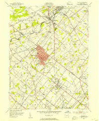
~ Telford PA topo map, 1:24000 scale, 7.5 X 7.5 Minute, Historical, 1953, updated 1954
Telford, Pennsylvania, USGS topographic map dated 1953.
Includes geographic coordinates (latitude and longitude). This topographic map is suitable for hiking, camping, and exploring, or framing it as a wall map.
Printed on-demand using high resolution imagery, on heavy weight and acid free paper, or alternatively on a variety of synthetic materials.
Topos available on paper, Waterproof, Poly, or Tyvek. Usually shipping rolled, unless combined with other folded maps in one order.
- Product Number: USGS-5328172
- Free digital map download (high-resolution, GeoPDF): Telford, Pennsylvania (file size: 9 MB)
- Map Size: please refer to the dimensions of the GeoPDF map above
- Weight (paper map): ca. 55 grams
- Map Type: POD USGS Topographic Map
- Map Series: HTMC
- Map Verison: Historical
- Cell ID: 44495
- Scan ID: 222124
- Imprint Year: 1954
- Woodland Tint: Yes
- Datum: NAD27
- Map Projection: Polyconic
- Map published by United States Geological Survey
- Map published by United States Army Corps of Engineers
- Map Language: English
- Scanner Resolution: 600 dpi
- Map Cell Name: Telford
- Grid size: 7.5 X 7.5 Minute
- Date on map: 1953
- Map Scale: 1:24000
- Geographical region: Pennsylvania, United States
Neighboring Maps:
All neighboring USGS topo maps are available for sale online at a variety of scales.
Spatial coverage:
Topo map Telford, Pennsylvania, covers the geographical area associated the following places:
- Mainland - Sellersville Heights - Hillcrest Estate - Reliance - Hunters Greene - Derstines - Colmar - Fortuna - Telford Commons - Elroy - Orchard Glen - Sellersville - Village at Salford Mill - Selsie Village - Mews at Wickford Commons - Perkasie - Silverdale - Fair Hill - Franconia - White Horse - Naceville - Yorkshire Commons - Franconia Hunt - Cambridge Reserve - Lions Gate II - Orvilla - Stonycrest - Estates at Tall Oaks - Schlichter - Bremen Woods - Pear Tree Village - Oak Grove Trailer Park - Lexington Leas - Earlington - Highland Park - Hunter Crest - Wynmere Hunt - Cross Gate - Telford - Unionville - Telford Chase - Bridle Run - Kimberwick Green - Cobblestone East - Bridgetown - Lexington Farms - Souderton - Derstine Estates - Dock Manor Terrace - Cowpath Village - Hidden Springs Mobile Home Park - Oak Wood East - Apple Tree Estates - Telford Hills - Banbury - Banbury Crossing - Trewigtown - Hatfield - Society Meadows - Pelham Green - Bramble Gate - Forrest View - Gristmill Run - Line Lexington - Hilpert - Summerwind - Pennfield Manor - Almont - Village Scene Trailer Park - Belcourt Manor
- Map Area ID: AREA40.37540.25-75.375-75.25
- Northwest corner Lat/Long code: USGSNW40.375-75.375
- Northeast corner Lat/Long code: USGSNE40.375-75.25
- Southwest corner Lat/Long code: USGSSW40.25-75.375
- Southeast corner Lat/Long code: USGSSE40.25-75.25
- Northern map edge Latitude: 40.375
- Southern map edge Latitude: 40.25
- Western map edge Longitude: -75.375
- Eastern map edge Longitude: -75.25


