
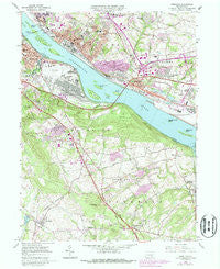
~ Steelton PA topo map, 1:24000 scale, 7.5 X 7.5 Minute, Historical, 1963, updated 1987
Steelton, Pennsylvania, USGS topographic map dated 1963.
Includes geographic coordinates (latitude and longitude). This topographic map is suitable for hiking, camping, and exploring, or framing it as a wall map.
Printed on-demand using high resolution imagery, on heavy weight and acid free paper, or alternatively on a variety of synthetic materials.
Topos available on paper, Waterproof, Poly, or Tyvek. Usually shipping rolled, unless combined with other folded maps in one order.
- Product Number: USGS-5327954
- Free digital map download (high-resolution, GeoPDF): Steelton, Pennsylvania (file size: 14 MB)
- Map Size: please refer to the dimensions of the GeoPDF map above
- Weight (paper map): ca. 55 grams
- Map Type: POD USGS Topographic Map
- Map Series: HTMC
- Map Verison: Historical
- Cell ID: 43056
- Scan ID: 223996
- Imprint Year: 1987
- Woodland Tint: Yes
- Photo Revision Year: 1987
- Aerial Photo Year: 1983
- Edit Year: 1987
- Field Check Year: 1963
- Datum: NAD27
- Map Projection: Polyconic
- Map published by United States Geological Survey
- Map Language: English
- Scanner Resolution: 600 dpi
- Map Cell Name: Steelton
- Grid size: 7.5 X 7.5 Minute
- Date on map: 1963
- Map Scale: 1:24000
- Geographical region: Pennsylvania, United States
Neighboring Maps:
All neighboring USGS topo maps are available for sale online at a variety of scales.
Spatial coverage:
Topo map Steelton, Pennsylvania, covers the geographical area associated the following places:
- Colonial Woods - Springville - Ramblewood - Highspire - Harvest Hills - Oberlin Gardens - Little Hollywood Mobile Home Park - Bressler - New Market - Willow Farms Mobile Home Park - Plainfield - Valley Green - Slaseman Mobile Home Park - Westfield Terrace - Laurel Wood Mobile Home Park - Goldsboro - Park Away Mobile Home Park - Colonial Woods South - Skyview Mobile Home Park - Remeos Mobile Home Park - Frogtown - Steelton - Meade Heights - Jednota - Oberlin - Cherry Hill - Swatara Crest - Redland Village - Marsh Run - Fairview Park - Reesers Summit - Greenwood Hills - Locust Manor Mobile Home Park - Valley Green Estates - Quaker Village - Yocumtown - Newberrytown - Lewisberry - Bass Lake - Enhaut - Ebenezer
- Map Area ID: AREA40.2540.125-76.875-76.75
- Northwest corner Lat/Long code: USGSNW40.25-76.875
- Northeast corner Lat/Long code: USGSNE40.25-76.75
- Southwest corner Lat/Long code: USGSSW40.125-76.875
- Southeast corner Lat/Long code: USGSSE40.125-76.75
- Northern map edge Latitude: 40.25
- Southern map edge Latitude: 40.125
- Western map edge Longitude: -76.875
- Eastern map edge Longitude: -76.75


