
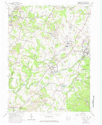
~ Smithfield PA topo map, 1:24000 scale, 7.5 X 7.5 Minute, Historical, 1964, updated 1973
Smithfield, Pennsylvania, USGS topographic map dated 1964.
Includes geographic coordinates (latitude and longitude). This topographic map is suitable for hiking, camping, and exploring, or framing it as a wall map.
Printed on-demand using high resolution imagery, on heavy weight and acid free paper, or alternatively on a variety of synthetic materials.
Topos available on paper, Waterproof, Poly, or Tyvek. Usually shipping rolled, unless combined with other folded maps in one order.
- Product Number: USGS-5327782
- Free digital map download (high-resolution, GeoPDF): Smithfield, Pennsylvania (file size: 10 MB)
- Map Size: please refer to the dimensions of the GeoPDF map above
- Weight (paper map): ca. 55 grams
- Map Type: POD USGS Topographic Map
- Map Series: HTMC
- Map Verison: Historical
- Cell ID: 41796
- Scan ID: 221884
- Imprint Year: 1973
- Woodland Tint: Yes
- Photo Revision Year: 1973
- Aerial Photo Year: 1973
- Field Check Year: 1964
- Datum: NAD27
- Map Projection: Polyconic
- Map published by United States Geological Survey
- Map Language: English
- Scanner Resolution: 600 dpi
- Map Cell Name: Smithfield
- Grid size: 7.5 X 7.5 Minute
- Date on map: 1964
- Map Scale: 1:24000
- Geographical region: Pennsylvania, United States
Neighboring Maps:
All neighboring USGS topo maps are available for sale online at a variety of scales.
Spatial coverage:
Topo map Smithfield, Pennsylvania, covers the geographical area associated the following places:
- York Run Junction - Old Frame - Amend - Plummer - Woodbridgetown - Ruble Mill - Smiley - Emery - Lewis Crossing - Cornish - Leckrone - Outcrop - Gilmore - Woodside - Dugan Hill - Morris Crossroads - Bowood - Highhouse - Deffenbaugh - Fairchance - Chadville - White House - Shoaf - Smithfield - Locust Hill - Haydentown - Collier - York Run
- Map Area ID: AREA39.87539.75-79.875-79.75
- Northwest corner Lat/Long code: USGSNW39.875-79.875
- Northeast corner Lat/Long code: USGSNE39.875-79.75
- Southwest corner Lat/Long code: USGSSW39.75-79.875
- Southeast corner Lat/Long code: USGSSE39.75-79.75
- Northern map edge Latitude: 39.875
- Southern map edge Latitude: 39.75
- Western map edge Longitude: -79.875
- Eastern map edge Longitude: -79.75


