
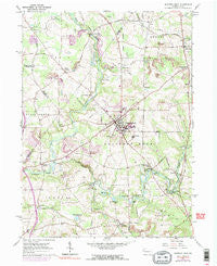
~ Slippery Rock PA topo map, 1:24000 scale, 7.5 X 7.5 Minute, Historical, 1961, updated 1990
Slippery Rock, Pennsylvania, USGS topographic map dated 1961.
Includes geographic coordinates (latitude and longitude). This topographic map is suitable for hiking, camping, and exploring, or framing it as a wall map.
Printed on-demand using high resolution imagery, on heavy weight and acid free paper, or alternatively on a variety of synthetic materials.
Topos available on paper, Waterproof, Poly, or Tyvek. Usually shipping rolled, unless combined with other folded maps in one order.
- Product Number: USGS-5327774
- Free digital map download (high-resolution, GeoPDF): Slippery Rock, Pennsylvania (file size: 12 MB)
- Map Size: please refer to the dimensions of the GeoPDF map above
- Weight (paper map): ca. 55 grams
- Map Type: POD USGS Topographic Map
- Map Series: HTMC
- Map Verison: Historical
- Cell ID: 41718
- Scan ID: 221867
- Imprint Year: 1990
- Woodland Tint: Yes
- Visual Version Number: 1
- Photo Inspection Year: 1977
- Photo Revision Year: 1970
- Aerial Photo Year: 1977
- Field Check Year: 1961
- Datum: NAD27
- Map Projection: Polyconic
- Map published by United States Geological Survey
- Map Language: English
- Scanner Resolution: 600 dpi
- Map Cell Name: Slippery Rock
- Grid size: 7.5 X 7.5 Minute
- Date on map: 1961
- Map Scale: 1:24000
- Geographical region: Pennsylvania, United States
Neighboring Maps:
All neighboring USGS topo maps are available for sale online at a variety of scales.
Spatial coverage:
Topo map Slippery Rock, Pennsylvania, covers the geographical area associated the following places:
- Keisters - West Liberty - Valcourt - Slippery Rock - Rock Falls Park - Heath - Carter - Christleys Mills - North Liberty - Crolls Mills - Forestville - Redmond - Moores Corners - Courtneys Mills - Currys Mills - Doughertys Mills - Carmona - Slippery Rock Park - Armstrong - Jacksville
- Map Area ID: AREA41.12541-80.125-80
- Northwest corner Lat/Long code: USGSNW41.125-80.125
- Northeast corner Lat/Long code: USGSNE41.125-80
- Southwest corner Lat/Long code: USGSSW41-80.125
- Southeast corner Lat/Long code: USGSSE41-80
- Northern map edge Latitude: 41.125
- Southern map edge Latitude: 41
- Western map edge Longitude: -80.125
- Eastern map edge Longitude: -80


