
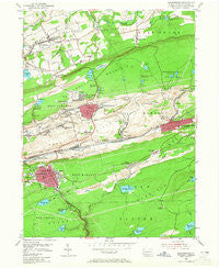
~ Shenandoah PA topo map, 1:24000 scale, 7.5 X 7.5 Minute, Historical, 1955, updated 1965
Shenandoah, Pennsylvania, USGS topographic map dated 1955.
Includes geographic coordinates (latitude and longitude). This topographic map is suitable for hiking, camping, and exploring, or framing it as a wall map.
Printed on-demand using high resolution imagery, on heavy weight and acid free paper, or alternatively on a variety of synthetic materials.
Topos available on paper, Waterproof, Poly, or Tyvek. Usually shipping rolled, unless combined with other folded maps in one order.
- Product Number: USGS-5327602
- Free digital map download (high-resolution, GeoPDF): Shenandoah, Pennsylvania (file size: 10 MB)
- Map Size: please refer to the dimensions of the GeoPDF map above
- Weight (paper map): ca. 55 grams
- Map Type: POD USGS Topographic Map
- Map Series: HTMC
- Map Verison: Historical
- Cell ID: 40989
- Scan ID: 221918
- Imprint Year: 1965
- Woodland Tint: Yes
- Aerial Photo Year: 1942
- Field Check Year: 1946
- Datum: NAD27
- Map Projection: Polyconic
- Map published by United States Geological Survey
- Map Language: English
- Scanner Resolution: 600 dpi
- Map Cell Name: Shenandoah
- Grid size: 7.5 X 7.5 Minute
- Date on map: 1955
- Map Scale: 1:24000
- Geographical region: Pennsylvania, United States
Neighboring Maps:
All neighboring USGS topo maps are available for sale online at a variety of scales.
Spatial coverage:
Topo map Shenandoah, Pennsylvania, covers the geographical area associated the following places:
- Pattersonville - Wetherill Junction - Turkey Run - Brandonville - Krebs - West William Penn - Newton Junction - Saint Nicholas - Lost Creek - Craigs - Morea - Bowmans - Weston Place - New Boston - Maple Hill - Upper Brownville - Yatesville - Gilberton - Ellen Gowan - Altamont - Mahanoy Plane - Shenandoah Heights - East William Penn - Shenandoah - Maizeville - Frackville - Bear Run Junction - Ringtown - Mahanoy City - Lower Brownville - Shoemakers - Englewood - Frackville Junction - Boston Run - Hills Terrace
- Map Area ID: AREA40.87540.75-76.25-76.125
- Northwest corner Lat/Long code: USGSNW40.875-76.25
- Northeast corner Lat/Long code: USGSNE40.875-76.125
- Southwest corner Lat/Long code: USGSSW40.75-76.25
- Southeast corner Lat/Long code: USGSSE40.75-76.125
- Northern map edge Latitude: 40.875
- Southern map edge Latitude: 40.75
- Western map edge Longitude: -76.25
- Eastern map edge Longitude: -76.125


