
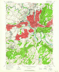
~ Reading PA topo map, 1:24000 scale, 7.5 X 7.5 Minute, Historical, 1956, updated 1964
Reading, Pennsylvania, USGS topographic map dated 1956.
Includes geographic coordinates (latitude and longitude). This topographic map is suitable for hiking, camping, and exploring, or framing it as a wall map.
Printed on-demand using high resolution imagery, on heavy weight and acid free paper, or alternatively on a variety of synthetic materials.
Topos available on paper, Waterproof, Poly, or Tyvek. Usually shipping rolled, unless combined with other folded maps in one order.
- Product Number: USGS-5327158
- Free digital map download (high-resolution, GeoPDF): Reading, Pennsylvania (file size: 12 MB)
- Map Size: please refer to the dimensions of the GeoPDF map above
- Weight (paper map): ca. 55 grams
- Map Type: POD USGS Topographic Map
- Map Series: HTMC
- Map Verison: Historical
- Cell ID: 37241
- Scan ID: 221592
- Imprint Year: 1964
- Woodland Tint: Yes
- Aerial Photo Year: 1947
- Field Check Year: 1956
- Datum: NAD27
- Map Projection: Polyconic
- Map published by United States Geological Survey
- Map Language: English
- Scanner Resolution: 600 dpi
- Map Cell Name: Reading
- Grid size: 7.5 X 7.5 Minute
- Date on map: 1956
- Map Scale: 1:24000
- Geographical region: Pennsylvania, United States
Neighboring Maps:
All neighboring USGS topo maps are available for sale online at a variety of scales.
Spatial coverage:
Topo map Reading, Pennsylvania, covers the geographical area associated the following places:
- Shillington - Northmont - College Heights - Angelica - West Wyomissing - Welsh Woods - Mohnton Lawn - Deerfield Village - Millmont - Neversink - Brookline - Kenhorst - Greenfields - Overbrook - Hampden Heights - Clover Park - Park Manor - Flying Hills - East Reading - Pennside - Pennwyn - Longview Estates - Berkshire Heights - West Lawn - Glenside - Springmont - Wyomissing Park - Stone Ridge - Klapperthall Junction - Woodgate - Greenfield Manor - Mifflin Park - Wyomissing - Grill - Ridgewood - Montrose - Spring Ridge - Mohnton - Oakbrook Terrace - Oakbrook - Crestwood South - Beverly Heights - Reading - Mount Penn - Wyomissing Hills - Lincoln Park - Highlands at Wyomissing - West Reading - Thomas Gardens - Freemanville - Van Reeds Mill - Birdland - Ridge Park - Montrose Manor - Crestwood - Colony Park - Seyfert
- Map Area ID: AREA40.37540.25-76-75.875
- Northwest corner Lat/Long code: USGSNW40.375-76
- Northeast corner Lat/Long code: USGSNE40.375-75.875
- Southwest corner Lat/Long code: USGSSW40.25-76
- Southeast corner Lat/Long code: USGSSE40.25-75.875
- Northern map edge Latitude: 40.375
- Southern map edge Latitude: 40.25
- Western map edge Longitude: -76
- Eastern map edge Longitude: -75.875


