
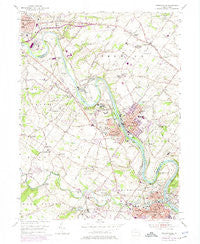
~ Phoenixville PA topo map, 1:24000 scale, 7.5 X 7.5 Minute, Historical, 1955, updated 1975
Phoenixville, Pennsylvania, USGS topographic map dated 1955.
Includes geographic coordinates (latitude and longitude). This topographic map is suitable for hiking, camping, and exploring, or framing it as a wall map.
Printed on-demand using high resolution imagery, on heavy weight and acid free paper, or alternatively on a variety of synthetic materials.
Topos available on paper, Waterproof, Poly, or Tyvek. Usually shipping rolled, unless combined with other folded maps in one order.
- Product Number: USGS-5326772
- Free digital map download (high-resolution, GeoPDF): Phoenixville, Pennsylvania (file size: 11 MB)
- Map Size: please refer to the dimensions of the GeoPDF map above
- Weight (paper map): ca. 55 grams
- Map Type: POD USGS Topographic Map
- Map Series: HTMC
- Map Verison: Historical
- Cell ID: 34992
- Scan ID: 221373
- Imprint Year: 1975
- Woodland Tint: Yes
- Photo Revision Year: 1973
- Aerial Photo Year: 1973
- Field Check Year: 1955
- Datum: NAD27
- Map Projection: Polyconic
- Map published by United States Geological Survey
- Map Language: English
- Scanner Resolution: 600 dpi
- Map Cell Name: Phoenixville
- Grid size: 7.5 X 7.5 Minute
- Date on map: 1955
- Map Scale: 1:24000
- Geographical region: Pennsylvania, United States
Neighboring Maps:
All neighboring USGS topo maps are available for sale online at a variety of scales.
Spatial coverage:
Topo map Phoenixville, Pennsylvania, covers the geographical area associated the following places:
- Limerick - Walnut Farms - William Penn Villas - Orchard Courts - Abbey Downs - Caines Creek - Village of Pickering Run - Lindberg Heights - Roboda - Ridgeview Terrace Trailer Park - Stony Run Mobile Home Park - Haverfield - Stoney Run Farms - Brownbacks - Winnie Tract - Ironsides - Royersford - Walnut Crossing - Terrace Hill - Bartons Meadows - Summer Chase - Ashford Green - Linfield - Cromby - Faircrest Farms - Parkerford - Herritage Ridge - Village of Mingo - Renninger Tract - Spring City - Parker Ford - Limerick Village Mobile Home Park - Linfield Farms - Winding River - Providence Forge - Wilsons Corner - Mont Clare - Chester Downs - Sheeder - Limerick Greene - Centre Creek Estates - Riverwalk - Fords Edge - Kimberton - Limerick Center - Oakwood Farms - Sanatoga - Dell at Muirfield - Barlow Heights - Ritter Estates - Chestnut Pointe - Golden Age Manor - Golf Ridge - Fricks Lock - Linfield Woods - Seven Stars - The Glen at Greenfields - Phoenixville - Mingo - Ramsgate-Providence Hunt - Shaners Trailer Park - Millers Mobile Home Park - Pennhurst - Montgomery Brooke - Rivers Bend - Hiestand - Sanatoga Commons - Coventry Terrace Mobile Home Park - Snowdenville
- Map Area ID: AREA40.2540.125-75.625-75.5
- Northwest corner Lat/Long code: USGSNW40.25-75.625
- Northeast corner Lat/Long code: USGSNE40.25-75.5
- Southwest corner Lat/Long code: USGSSW40.125-75.625
- Southeast corner Lat/Long code: USGSSE40.125-75.5
- Northern map edge Latitude: 40.25
- Southern map edge Latitude: 40.125
- Western map edge Longitude: -75.625
- Eastern map edge Longitude: -75.5


