
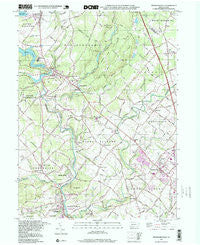
~ Perkiomenville PA topo map, 1:24000 scale, 7.5 X 7.5 Minute, Historical, 1997, updated 1999
Perkiomenville, Pennsylvania, USGS topographic map dated 1997.
Includes geographic coordinates (latitude and longitude). This topographic map is suitable for hiking, camping, and exploring, or framing it as a wall map.
Printed on-demand using high resolution imagery, on heavy weight and acid free paper, or alternatively on a variety of synthetic materials.
Topos available on paper, Waterproof, Poly, or Tyvek. Usually shipping rolled, unless combined with other folded maps in one order.
- Product Number: USGS-5326734
- Free digital map download (high-resolution, GeoPDF): Perkiomenville, Pennsylvania (file size: 11 MB)
- Map Size: please refer to the dimensions of the GeoPDF map above
- Weight (paper map): ca. 55 grams
- Map Type: POD USGS Topographic Map
- Map Series: HTMC
- Map Verison: Historical
- Cell ID: 34795
- Scan ID: 223750
- Imprint Year: 1999
- Woodland Tint: Yes
- Photo Inspection Year: 1997
- Aerial Photo Year: 1997
- Field Check Year: 1960
- Datum: NAD27
- Map Projection: Lambert Conformal Conic
- Map published by United States Geological Survey
- Map Language: English
- Scanner Resolution: 600 dpi
- Map Cell Name: Perkiomenville
- Grid size: 7.5 X 7.5 Minute
- Date on map: 1997
- Map Scale: 1:24000
- Geographical region: Pennsylvania, United States
Neighboring Maps:
All neighboring USGS topo maps are available for sale online at a variety of scales.
Spatial coverage:
Topo map Perkiomenville, Pennsylvania, covers the geographical area associated the following places:
- Cheswyck - Salford Ridge - Woxall - Shirks Corner - Bellingham Knoll - Green Lane - Indian Crest Farms - Vernfield - Harleysville - Spring Mount - Harleysville Homestead - Green Hill Mobile Home Park - Bergey - Red Hill - Rosecliff - Penn Oak Manor - Hickory Tree Estates - The Heathers - Sumneytown - Hendricks - Salfordville - Tylersport - Silverbrook Farms - Zieglersville - Argus - Village Brook Estate - Schwenksville - Stormfield - Kratz - Harley Glen - Lederach - Morwood - Spring Mount Summit - Delphi - Kingscote - Perkiomenville - Salford - Salford Pond - Marlboroville
- Map Area ID: AREA40.37540.25-75.5-75.375
- Northwest corner Lat/Long code: USGSNW40.375-75.5
- Northeast corner Lat/Long code: USGSNE40.375-75.375
- Southwest corner Lat/Long code: USGSSW40.25-75.5
- Southeast corner Lat/Long code: USGSSE40.25-75.375
- Northern map edge Latitude: 40.375
- Southern map edge Latitude: 40.25
- Western map edge Longitude: -75.5
- Eastern map edge Longitude: -75.375


