
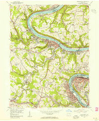
~ Monongahela PA topo map, 1:24000 scale, 7.5 X 7.5 Minute, Historical, 1954, updated 1955
Monongahela, Pennsylvania, USGS topographic map dated 1954.
Includes geographic coordinates (latitude and longitude). This topographic map is suitable for hiking, camping, and exploring, or framing it as a wall map.
Printed on-demand using high resolution imagery, on heavy weight and acid free paper, or alternatively on a variety of synthetic materials.
Topos available on paper, Waterproof, Poly, or Tyvek. Usually shipping rolled, unless combined with other folded maps in one order.
- Product Number: USGS-5326010
- Free digital map download (high-resolution, GeoPDF): Monongahela, Pennsylvania (file size: 14 MB)
- Map Size: please refer to the dimensions of the GeoPDF map above
- Weight (paper map): ca. 55 grams
- Map Type: POD USGS Topographic Map
- Map Series: HTMC
- Map Verison: Historical
- Cell ID: 29862
- Scan ID: 171636
- Imprint Year: 1955
- Woodland Tint: Yes
- Aerial Photo Year: 1952
- Field Check Year: 1954
- Datum: NAD27
- Map Projection: Polyconic
- Map published by United States Geological Survey
- Map Language: English
- Scanner Resolution: 600 dpi
- Map Cell Name: Monongahela
- Grid size: 7.5 X 7.5 Minute
- Date on map: 1954
- Map Scale: 1:24000
- Geographical region: Pennsylvania, United States
Neighboring Maps:
All neighboring USGS topo maps are available for sale online at a variety of scales.
Spatial coverage:
Topo map Monongahela, Pennsylvania, covers the geographical area associated the following places:
- Ghennes Heights - Gallatin - Gibson - Hilldale - Crookham - Gibsonton - Eldora - Manown - Charleroi - Rogers Stop - Riverview - Sampson - Twin Bridges - Black Diamond - Hazel Kirk - Jonestown - East Monongahela - Froman - Ginger Hill - Baidland - Sunny Side - River Hill - Frye - Warner - Wallace - Elben - Wickerham Manor - Redds Mill - Victory Hills - Monessen - Courtney - Huston Run - Shire Oaks - New Eagle - Sudan - Van Voorhis - River View - Monongahela - North Charleroi - Bunola - Lockview - East Charleroi - Fisher - Elkhorn - Cracker Jack
- Map Area ID: AREA40.2540.125-80-79.875
- Northwest corner Lat/Long code: USGSNW40.25-80
- Northeast corner Lat/Long code: USGSNE40.25-79.875
- Southwest corner Lat/Long code: USGSSW40.125-80
- Southeast corner Lat/Long code: USGSSE40.125-79.875
- Northern map edge Latitude: 40.25
- Southern map edge Latitude: 40.125
- Western map edge Longitude: -80
- Eastern map edge Longitude: -79.875


