
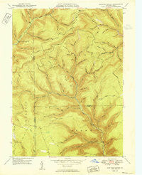
~ Lee Fire Tower PA topo map, 1:24000 scale, 7.5 X 7.5 Minute, Historical, 1950
Lee Fire Tower, Pennsylvania, USGS topographic map dated 1950.
Includes geographic coordinates (latitude and longitude). This topographic map is suitable for hiking, camping, and exploring, or framing it as a wall map.
Printed on-demand using high resolution imagery, on heavy weight and acid free paper, or alternatively on a variety of synthetic materials.
Topos available on paper, Waterproof, Poly, or Tyvek. Usually shipping rolled, unless combined with other folded maps in one order.
- Product Number: USGS-5325228
- Free digital map download (high-resolution, GeoPDF): Lee Fire Tower, Pennsylvania (file size: 11 MB)
- Map Size: please refer to the dimensions of the GeoPDF map above
- Weight (paper map): ca. 55 grams
- Map Type: POD USGS Topographic Map
- Map Series: HTMC
- Map Verison: Historical
- Cell ID: 25299
- Scan ID: 172080
- Woodland Tint: Yes
- Aerial Photo Year: 1942
- Field Check Year: 1947
- Datum: NAD27
- Map Projection: Polyconic
- Map published by United States Geological Survey
- Map Language: English
- Scanner Resolution: 600 dpi
- Map Cell Name: Lee Fire Tower
- Grid size: 7.5 X 7.5 Minute
- Date on map: 1950
- Map Scale: 1:24000
- Geographical region: Pennsylvania, United States
Neighboring Maps:
All neighboring USGS topo maps are available for sale online at a variety of scales.
Spatial coverage:
Topo map Lee Fire Tower, Pennsylvania, covers the geographical area associated the following places:
- Cushman Branch - Dixon Hollow - Apple Tree Hollow - Randall Hollow - Clay Mine Trail - Chestnut Trail - Red Run - Camp Trail - Big Dam Hollow Trail - Manor Fork - Farmer Shanty Trail - Lee Fire Tower - Indian Bill Hollow - Morris Trail - Daugherty Branch - Misner Hollow - Buck Run - Reynolds Spring Trail - Wildcat Hollow - Township of Elk - Apple Tree Trail - Little Daugherty Run - Birch Hollow - Sprinkling Canal Hollow - Carson Hollow - Putt Hollow - Gaswell Trail - Camp Hollow - Francis Branch - Bear Run - Jenkins Hollow - Hedgehog Hollow - Cherry Run - Locks Hollow - Winnie Hollow - Brooks Trail - Dyer Pike Trail - Water Trough Trail - Tinsmith Hollow - Morris Run - Dry Hollow - Black Forest Inn Airport (historical) - Dark Hollow - Kramer Hollow - Carson Hollow Trail - Jug Hollow - Brooks Hollow - Gas Well Hollow - Farmer Shanty Hollow - Little Morris Run - Butler Hollow - Rocky Run Trail - Sliders Branch - Stony Valley - Algerine Wild Area - Kramer Trail - Dry Hollow - Big Dam Hollow - Butternut Hollow - King Smith Hollow - Schoolhouse Hollow - Brackman Hollow - Rocky Run - Filmore Hollow - Welch Hollow - Cushman Trail - Little Morris Trail - Fill Trestle Trail - Beaver Hollow - Sliders Dam
- Map Area ID: AREA41.62541.5-77.625-77.5
- Northwest corner Lat/Long code: USGSNW41.625-77.625
- Northeast corner Lat/Long code: USGSNE41.625-77.5
- Southwest corner Lat/Long code: USGSSW41.5-77.625
- Southeast corner Lat/Long code: USGSSE41.5-77.5
- Northern map edge Latitude: 41.625
- Southern map edge Latitude: 41.5
- Western map edge Longitude: -77.625
- Eastern map edge Longitude: -77.5


