
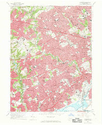
~ Lansdowne PA topo map, 1:24000 scale, 7.5 X 7.5 Minute, Historical, 1967, updated 1969
Lansdowne, Pennsylvania, USGS topographic map dated 1967.
Includes geographic coordinates (latitude and longitude). This topographic map is suitable for hiking, camping, and exploring, or framing it as a wall map.
Printed on-demand using high resolution imagery, on heavy weight and acid free paper, or alternatively on a variety of synthetic materials.
Topos available on paper, Waterproof, Poly, or Tyvek. Usually shipping rolled, unless combined with other folded maps in one order.
- Product Number: USGS-5325160
- Free digital map download (high-resolution, GeoPDF): Lansdowne, Pennsylvania (file size: 16 MB)
- Map Size: please refer to the dimensions of the GeoPDF map above
- Weight (paper map): ca. 55 grams
- Map Type: POD USGS Topographic Map
- Map Series: HTMC
- Map Verison: Historical
- Cell ID: 24937
- Scan ID: 172165
- Imprint Year: 1969
- Woodland Tint: Yes
- Aerial Photo Year: 1965
- Field Check Year: 1967
- Survey Year: 1940
- Datum: NAD27
- Map Projection: Polyconic
- Map published by United States Geological Survey
- Map Language: English
- Scanner Resolution: 600 dpi
- Map Cell Name: Lansdowne
- Grid size: 7.5 X 7.5 Minute
- Date on map: 1967
- Map Scale: 1:24000
- Geographical region: Pennsylvania, United States
Neighboring Maps:
All neighboring USGS topo maps are available for sale online at a variety of scales.
Spatial coverage:
Topo map Lansdowne, Pennsylvania, covers the geographical area associated the following places:
- Coopertown (historical) - Norwood - Prospect Park - Lapidea - East Lansdowne - Villas at Golf View Estates - Holmes - Primos - Rutledge - Summits Edge - Kellyville - Pilgrim Gardens - Merion Park - West Ridley Park - Woodlyn - Folcroft - Westbrook Park - Millbourne - Bon Air - Marplewoods - Aronimink - Adele - West Gate Hills - Ardmore Park - Drexel Hill - Stonehurst - Foxcroft - Yeadon - Merion Gardens - Lansdowne - Beverly Hills - Lawrence Park - Milmont - Waterville - Manoa - Addingham - Morton - Garrettford - Broomall - Sharon Hill - Kirklyn - Pine Ridge - Academy - Clifton Heights - Secane - Burmont - Grassland - Woods at Langford - Oakmont - Bywood - Highland Park - Brookthorpe Hills - Moore - Haverwood - Havertown - Oak Lane - Boon - Fernwood - Colwyn - Richland - Penn Wynne - Wallingford - Llanwellyn - Swarthmore - Californian - Penfield - Aldan - Upper Darby - Brookline - Coreze - Collingdale - Avendale - Darby - Glenolden - Pendle Hill - Folsom - Wyndom - Garden City - Llanerch - Bryn Mawr Place - Springfield - Ridley Park - Allgates
- Map Area ID: AREA4039.875-75.375-75.25
- Northwest corner Lat/Long code: USGSNW40-75.375
- Northeast corner Lat/Long code: USGSNE40-75.25
- Southwest corner Lat/Long code: USGSSW39.875-75.375
- Southeast corner Lat/Long code: USGSSE39.875-75.25
- Northern map edge Latitude: 40
- Southern map edge Latitude: 39.875
- Western map edge Longitude: -75.375
- Eastern map edge Longitude: -75.25


