
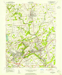
~ Langhorne PA topo map, 1:24000 scale, 7.5 X 7.5 Minute, Historical, 1953, updated 1955
Langhorne, Pennsylvania, USGS topographic map dated 1953.
Includes geographic coordinates (latitude and longitude). This topographic map is suitable for hiking, camping, and exploring, or framing it as a wall map.
Printed on-demand using high resolution imagery, on heavy weight and acid free paper, or alternatively on a variety of synthetic materials.
Topos available on paper, Waterproof, Poly, or Tyvek. Usually shipping rolled, unless combined with other folded maps in one order.
- Product Number: USGS-5325130
- Free digital map download (high-resolution, GeoPDF): Langhorne, Pennsylvania (file size: 10 MB)
- Map Size: please refer to the dimensions of the GeoPDF map above
- Weight (paper map): ca. 55 grams
- Map Type: POD USGS Topographic Map
- Map Series: HTMC
- Map Verison: Historical
- Cell ID: 24919
- Scan ID: 171048
- Imprint Year: 1955
- Woodland Tint: Yes
- Aerial Photo Year: 1942
- Datum: NAD27
- Map Projection: Polyconic
- Map published by United States Geological Survey
- Map published by United States Army Corps of Engineers
- Map published by United States Army
- Map Language: English
- Scanner Resolution: 600 dpi
- Map Cell Name: Langhorne
- Grid size: 7.5 X 7.5 Minute
- Date on map: 1953
- Map Scale: 1:24000
- Geographical region: Pennsylvania, United States
Neighboring Maps:
All neighboring USGS topo maps are available for sale online at a variety of scales.
Spatial coverage:
Topo map Langhorne, Pennsylvania, covers the geographical area associated the following places:
- Bridgetown - Holland - Neshaminy (historical) - Oakford - Trevose - Saint Leonard - Neshaminy Hills - Newtown - Parkland Heights - Hellings Corner - Elmwood Terrace - Idlewood - Fairless Junction - Langhorne - Penndel - Siles - Maple Point - Midway - Woodbourne - Trevose Heights - Bucktoe - Calico Corner - Bridgetown - Langhorne Gardens - La Trappe - Hulmeville Terrace - Neshaminy Falls - Langhorne Terrace - Villas of Middletown - Langhorne Manor - Neshaminy Heights - Janney - Linconia - Glenlake - Woodside - Parkland - Hulmeville - Village Shires - Neshaminy Woods - Edgeboro
- Map Area ID: AREA40.2540.125-75-74.875
- Northwest corner Lat/Long code: USGSNW40.25-75
- Northeast corner Lat/Long code: USGSNE40.25-74.875
- Southwest corner Lat/Long code: USGSSW40.125-75
- Southeast corner Lat/Long code: USGSSE40.125-74.875
- Northern map edge Latitude: 40.25
- Southern map edge Latitude: 40.125
- Western map edge Longitude: -75
- Eastern map edge Longitude: -74.875


