
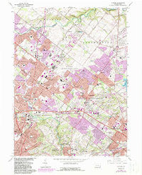
~ Hatboro PA topo map, 1:24000 scale, 7.5 X 7.5 Minute, Historical, 1966, updated 1983
Hatboro, Pennsylvania, USGS topographic map dated 1966.
Includes geographic coordinates (latitude and longitude). This topographic map is suitable for hiking, camping, and exploring, or framing it as a wall map.
Printed on-demand using high resolution imagery, on heavy weight and acid free paper, or alternatively on a variety of synthetic materials.
Topos available on paper, Waterproof, Poly, or Tyvek. Usually shipping rolled, unless combined with other folded maps in one order.
- Product Number: USGS-5324476
- Free digital map download (high-resolution, GeoPDF): Hatboro, Pennsylvania (file size: 16 MB)
- Map Size: please refer to the dimensions of the GeoPDF map above
- Weight (paper map): ca. 55 grams
- Map Type: POD USGS Topographic Map
- Map Series: HTMC
- Map Verison: Historical
- Cell ID: 70327
- Scan ID: 171933
- Imprint Year: 1983
- Woodland Tint: Yes
- Visual Version Number: 1
- Photo Revision Year: 1983
- Aerial Photo Year: 1981
- Edit Year: 1983
- Field Check Year: 1966
- Datum: NAD27
- Map Projection: Polyconic
- Map published by United States Geological Survey
- Map Language: English
- Scanner Resolution: 600 dpi
- Map Cell Name: Hatboro
- Grid size: 7.5 X 7.5 Minute
- Date on map: 1966
- Map Scale: 1:24000
- Geographical region: Pennsylvania, United States
Neighboring Maps:
All neighboring USGS topo maps are available for sale online at a variety of scales.
Spatial coverage:
Topo map Hatboro, Pennsylvania, covers the geographical area associated the following places:
- Hidden Creek Estates - Byberry - Long Lane Farms III - Blair Mill Village West - Rubicam - Traymore - Jamestown Village - Richboro - Warminster - Hidden Creek Phase II - Arcadia at Inverness Glen - Warminster Heights - Buttonwood Farms - Mill Run - Regency Park Towers - Shoemak Village - Buckridge Farms - Brittany Farms at Equus - Johnsville - Heaton - Paper Mills - Bryn Athyn - Centennial Station - Ivygreene Run - Rosewood Park - Terwood - Hatboro - Robert Bruce - Hartsville - Sorrelhorse - Southampton - Churchville - Breadysville - Davisville - Pinewoods - Casey Highlands - Westbury - Somerton Estate - Fulmor - County Line - Ivyland - Woodmont - Jacksonville - Casey Village - Clearbrook Village - Leary Trace Park - Grenoble - Morganville - Penns Gate - Somerton Forge - Alnwick - Warminster Village - Saxony Manor - Shoemaker Village - Blair Mill Village East - Bonair - Feasterville - Lacey Park - Street Road - Stony Brook - Hamptontowne - Ivybrook Ridge - Willow Grove - Cornell
- Map Area ID: AREA40.2540.125-75.125-75
- Northwest corner Lat/Long code: USGSNW40.25-75.125
- Northeast corner Lat/Long code: USGSNE40.25-75
- Southwest corner Lat/Long code: USGSSW40.125-75.125
- Southeast corner Lat/Long code: USGSSE40.125-75
- Northern map edge Latitude: 40.25
- Southern map edge Latitude: 40.125
- Western map edge Longitude: -75.125
- Eastern map edge Longitude: -75


