
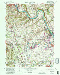
~ Cementon PA topo map, 1:24000 scale, 7.5 X 7.5 Minute, Historical, 1992, updated 1995
Cementon, Pennsylvania, USGS topographic map dated 1992.
Includes geographic coordinates (latitude and longitude). This topographic map is suitable for hiking, camping, and exploring, or framing it as a wall map.
Printed on-demand using high resolution imagery, on heavy weight and acid free paper, or alternatively on a variety of synthetic materials.
Topos available on paper, Waterproof, Poly, or Tyvek. Usually shipping rolled, unless combined with other folded maps in one order.
- Product Number: USGS-5322720
- Free digital map download (high-resolution, GeoPDF): Cementon, Pennsylvania (file size: 15 MB)
- Map Size: please refer to the dimensions of the GeoPDF map above
- Weight (paper map): ca. 55 grams
- Map Type: POD USGS Topographic Map
- Map Series: HTMC
- Map Verison: Historical
- Cell ID: 7891
- Scan ID: 223190
- Imprint Year: 1995
- Woodland Tint: Yes
- Aerial Photo Year: 1981
- Edit Year: 1983
- Field Check Year: 1964
- Datum: NAD27
- Map Projection: Lambert Conformal Conic
- Map published by United States Geological Survey
- Map Language: English
- Scanner Resolution: 600 dpi
- Map Cell Name: Cementon
- Grid size: 7.5 X 7.5 Minute
- Date on map: 1992
- Map Scale: 1:24000
- Geographical region: Pennsylvania, United States
Neighboring Maps:
All neighboring USGS topo maps are available for sale online at a variety of scales.
Spatial coverage:
Topo map Cementon, Pennsylvania, covers the geographical area associated the following places:
- Egypt - Coffeetown - Raubs Mills - Home Park - Trout Creek - Neffs - Slatington - Unionville - Cementon - Ironton - North Coplay - Meyersville - Ruchsville - Balliettsville - River View - Orefield - Mechanicsville - Scherersville - Walnutport Acres - Treichlers - Walnut Acres - Friedens - Mickleys Gardens - Dewey Heights - Stiles - Ormrod - Metamora Station - Laurys Station - Pennsville - Rockdale - Shankweilers - Wellington - Greenawalds - Scheidy - Lockport - Lockridge - Kernsville - Williamstown - Rising Sun - Schnecksville - Seiple - Newhard
- Map Area ID: AREA40.7540.625-75.625-75.5
- Northwest corner Lat/Long code: USGSNW40.75-75.625
- Northeast corner Lat/Long code: USGSNE40.75-75.5
- Southwest corner Lat/Long code: USGSSW40.625-75.625
- Southeast corner Lat/Long code: USGSSE40.625-75.5
- Northern map edge Latitude: 40.75
- Southern map edge Latitude: 40.625
- Western map edge Longitude: -75.625
- Eastern map edge Longitude: -75.5


