
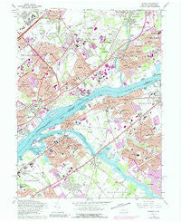
~ Beverly NJ topo map, 1:24000 scale, 7.5 X 7.5 Minute, Historical, 1966, updated 1990
Beverly, New Jersey, USGS topographic map dated 1966.
Includes geographic coordinates (latitude and longitude). This topographic map is suitable for hiking, camping, and exploring, or framing it as a wall map.
Printed on-demand using high resolution imagery, on heavy weight and acid free paper, or alternatively on a variety of synthetic materials.
Topos available on paper, Waterproof, Poly, or Tyvek. Usually shipping rolled, unless combined with other folded maps in one order.
- Product Number: USGS-5322202
- Free digital map download (high-resolution, GeoPDF): Beverly, New Jersey (file size: 14 MB)
- Map Size: please refer to the dimensions of the GeoPDF map above
- Weight (paper map): ca. 55 grams
- Map Type: POD USGS Topographic Map
- Map Series: HTMC
- Map Verison: Historical
- Cell ID: 3584
- Scan ID: 223448
- Imprint Year: 1990
- Woodland Tint: Yes
- Photo Revision Year: 1973
- Aerial Photo Year: 1973
- Field Check Year: 1966
- Datum: NAD27
- Map Projection: Polyconic
- Map published by United States Geological Survey
- Map published by United States Army
- Map Language: English
- Scanner Resolution: 600 dpi
- Map Cell Name: Beverly
- Grid size: 7.5 X 7.5 Minute
- Date on map: 1966
- Map Scale: 1:24000
- Geographical region: New Jersey, United States
Neighboring Maps:
All neighboring USGS topo maps are available for sale online at a variety of scales.
Spatial coverage:
Topo map Beverly, New Jersey, covers the geographical area associated the following places:
- Parkwood Manor - Belardy - Modena Park - Millbrook Park - Eddington - Somerset Park - Buckingham Park - Chestnut Wood Village - West Torresdale - Newportville Terrace - Borton Landing - Fergusonville - Byberry - Milbrook - Nottingham - Plaza Park - Croydon Heights - Pennypacker Park - Edgewater Park - Grundys Corner - Riverside - Cornwell - Stanwood - Millside Heights - Bridgeboro - Cambridge - Kearney - Martins Beach - Flushing - Delaire Landing - Country Club Ridge - Sharper - Andalusia - Garfield Park - Beverly - Eddington Gardens - Eddington Park - Glen Ashton Farms - Cornwells Heights - Echo Reach - East Riverton - Echo Beach - Riverton - Academy Garden - Centre Plaza Shopping Center - Rockdale - Bellview - Devon Close - Brookwood - New Albany - Torresdale Manor - Morrell Park - Riverside Park - Byberry - Croydon Acres - Delanco - Capitol Hill - Skin Corner - Crestmont Farms - Carriage Stop - Cornwells Manor - West Bristol - Bridgewater - Fairview - Croydon - Bensalem - Normandy - Ellerslie - Franklin Park - Twin Hill Park - Charleston - Newportville - Maple Shade - Cooperstown - Union Landing - Mechanicsville - Longmead Farms
- Map Area ID: AREA40.12540-75-74.875
- Northwest corner Lat/Long code: USGSNW40.125-75
- Northeast corner Lat/Long code: USGSNE40.125-74.875
- Southwest corner Lat/Long code: USGSSW40-75
- Southeast corner Lat/Long code: USGSSE40-74.875
- Northern map edge Latitude: 40.125
- Southern map edge Latitude: 40
- Western map edge Longitude: -75
- Eastern map edge Longitude: -74.875


