
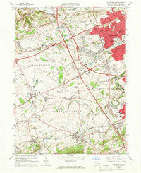
~ Allentown West PA topo map, 1:24000 scale, 7.5 X 7.5 Minute, Historical, 1964, updated 1966
Allentown West, Pennsylvania, USGS topographic map dated 1964.
Includes geographic coordinates (latitude and longitude). This topographic map is suitable for hiking, camping, and exploring, or framing it as a wall map.
Printed on-demand using high resolution imagery, on heavy weight and acid free paper, or alternatively on a variety of synthetic materials.
Topos available on paper, Waterproof, Poly, or Tyvek. Usually shipping rolled, unless combined with other folded maps in one order.
- Product Number: USGS-5321702
- Free digital map download (high-resolution, GeoPDF): Allentown West, Pennsylvania (file size: 11 MB)
- Map Size: please refer to the dimensions of the GeoPDF map above
- Weight (paper map): ca. 55 grams
- Map Type: POD USGS Topographic Map
- Map Series: HTMC
- Map Verison: Historical
- Cell ID: 625
- Scan ID: 167949
- Imprint Year: 1966
- Woodland Tint: Yes
- Aerial Photo Year: 1962
- Field Check Year: 1964
- Datum: NAD27
- Map Projection: Polyconic
- Map published by United States Geological Survey
- Map Language: English
- Scanner Resolution: 600 dpi
- Map Cell Name: Allentown West
- Grid size: 7.5 X 7.5 Minute
- Date on map: 1964
- Map Scale: 1:24000
- Geographical region: Pennsylvania, United States
Neighboring Maps:
All neighboring USGS topo maps are available for sale online at a variety of scales.
Spatial coverage:
Topo map Allentown West, Pennsylvania, covers the geographical area associated the following places:
- Chapman - Kuhnsville - Dorneyville - Woodlawn - East Fogelsville - Griesemersville - Wescosville - Wennersville - Trexlertown - Haines - Cetronia - Spring Creek - Weilersville - Westwood Heights - Litzenberg - Alburtis - Bungalow Park - Walbert - East Texas - Stetlersville - Park Way Manor - Crackersport - Eckert (historical) - Hillside - Macungie - Minesite - Guthsville - Hilltown - Guth - Sterlingworth - Centreville - Parkside Courts - Cedarbrook County Home - Ruppsville - Ancient Oaks - Krocksville
- Map Area ID: AREA40.62540.5-75.625-75.5
- Northwest corner Lat/Long code: USGSNW40.625-75.625
- Northeast corner Lat/Long code: USGSNE40.625-75.5
- Southwest corner Lat/Long code: USGSSW40.5-75.625
- Southeast corner Lat/Long code: USGSSE40.5-75.5
- Northern map edge Latitude: 40.625
- Southern map edge Latitude: 40.5
- Western map edge Longitude: -75.625
- Eastern map edge Longitude: -75.5


