
~ Toledo OH topo map, 1:250000 scale, 1 X 2 Degree, Historical, 1956, updated 1979
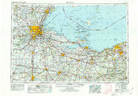
Toledo, Ohio, USGS topographic map dated 1956.
Includes geographic coordinates (latitude and longitude). This topographic map is suitable for hiking, camping, and exploring, or framing it as a wall map.
Printed on-demand using high resolution imagery, on heavy weight and acid free paper, or alternatively on a variety of synthetic materials.
Topos available on paper, Waterproof, Poly, or Tyvek. Usually shipping rolled, unless combined with other folded maps in one order.
- Product Number: USGS-5321608
- Free digital map download (high-resolution, GeoPDF): Toledo, Ohio (file size: 18 MB)
- Map Size: please refer to the dimensions of the GeoPDF map above
- Weight (paper map): ca. 55 grams
- Map Type: POD USGS Topographic Map
- Map Series: HTMC
- Map Verison: Historical
- Cell ID: 69054
- Scan ID: 226808
- Imprint Year: 1979
- Woodland Tint: Yes
- Aerial Photo Year: 1977
- Edit Year: 1978
- Field Check Year: 1956
- Datum: Unstated
- Map Projection: Transverse Mercator
- Map published by United States Geological Survey
- Map Language: English
- Scanner Resolution: 600 dpi
- Map Cell Name: Toledo
- Grid size: 1 X 2 Degree
- Date on map: 1956
- Map Scale: 1:250000
- Geographical region: Ohio, United States
Neighboring Maps:
All neighboring USGS topo maps are available for sale online at a variety of scales.
Spatial coverage:
Topo map Toledo, Ohio, covers the geographical area associated the following places:
- Folger (historical) - Kipton - Shorewood Village - Presque Isle (historical) - North Pointe Place Mobile Home Park - East Norwalk - Cedar Creek Woods - Ida - Vincent - Mid City Mobile Homes - Leslie (historical) - Johnston Corners - Indian Trail Estates - Hartland Station - Pine Villas - Perrysburg Heights - Frances Gardens - Siam - Treadway (historical) - New Rochester - Lakemont Landing - Republic - Riverford - Fort Meigs Place - Ai - Isle Saint George - Celeryville - La Salle - Berlin Heights - McClure - Friendly Village I Mobile Home Park - South Findlay - Wintergarden Heights - Indian Creek - Weavers Corners - Brownhelm Station - Avon Center - Fremont - Maplewood Park - Northtown Meadows Mobile Home Park - Fourmile House Corner - Gabels Corner - Strongs Ridge - Estral Beach - Moffitt (historical) - Fitchville - Weston Trailer Court - Mount Carmel - Hessville - Arrowhead Lake - Ridgeway - Springbrook - Cherry Knoll Mobile Park - Standardsburg - Bairdstown - Cromers - Colby - Bradner - Roachton - East Swanton - Swander - Bascom - Bayer Trailer Court - Sunnyside - Boulevard - Luna Pier - Ballville - West Millgrove - Clearview Mobile Park - Shiperd Circle - Deweyville - North Ridgeville (historical) - Oregon - Center - Rochester - Birmingham - Parkertown - Rye beach - Semples - Mineyahta-on-the Bay - Hull Prairie - Coach Light Estates Mobile Home Park - Digby - Hopewell Heights - Homewood - Erie - Hunts Corners - Muncie Hollow - Burgoon - Risingsun - Chaska Beach - Angus - Lindbergh Heights - Old Fort - Pointe aux Peaux - The Meadows - Cresceus Farms - Maple Grove - Woodville Gardens - Vermilion
- Map Area ID: AREA4241-84-82
- Northwest corner Lat/Long code: USGSNW42-84
- Northeast corner Lat/Long code: USGSNE42-82
- Southwest corner Lat/Long code: USGSSW41-84
- Southeast corner Lat/Long code: USGSSE41-82
- Northern map edge Latitude: 42
- Southern map edge Latitude: 41
- Western map edge Longitude: -84
- Eastern map edge Longitude: -82


