
~ Toledo OH topo map, 1:250000 scale, 1 X 2 Degree, Historical, 1956, updated 1979
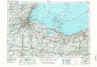
Toledo, Ohio, USGS topographic map dated 1956.
Includes geographic coordinates (latitude and longitude). This topographic map is suitable for hiking, camping, and exploring, or framing it as a wall map.
Printed on-demand using high resolution imagery, on heavy weight and acid free paper, or alternatively on a variety of synthetic materials.
Topos available on paper, Waterproof, Poly, or Tyvek. Usually shipping rolled, unless combined with other folded maps in one order.
- Product Number: USGS-5321606
- Free digital map download (high-resolution, GeoPDF): Toledo, Ohio (file size: 18 MB)
- Map Size: please refer to the dimensions of the GeoPDF map above
- Weight (paper map): ca. 55 grams
- Map Type: POD USGS Topographic Map
- Map Series: HTMC
- Map Verison: Historical
- Cell ID: 69054
- Scan ID: 226807
- Imprint Year: 1979
- Woodland Tint: Yes
- Visual Version Number: 1
- Photo Revision Year: 1978
- Aerial Photo Year: 1977
- Edit Year: 1978
- Field Check Year: 1956
- Datum: Unstated
- Map Projection: Transverse Mercator
- Map published by United States Geological Survey
- Map published by: Military, Other
- Map Language: English
- Scanner Resolution: 600 dpi
- Map Cell Name: Toledo
- Grid size: 1 X 2 Degree
- Date on map: 1956
- Map Scale: 1:250000
- Geographical region: Ohio, United States
Neighboring Maps:
All neighboring USGS topo maps are available for sale online at a variety of scales.
Spatial coverage:
Topo map Toledo, Ohio, covers the geographical area associated the following places:
- Harbor Acres - Fairview Lanes - Nova - Avon Lake - Eagle Point Colony - White Fox - Mount Pleasant - Clinton Mobile Home Court - Petersburg Junction - La Salle - Willow Haven Trailer Court - Riverview Trailer Court - Riverdale (historical) - Madison Addition - Pemberville - Wood Lake Mobile Home Park - Beaver Park - Holloway - Crissey - Maple Hill Mobile Home Park - Hille Farms - Orchard Beach - Cromers - Cherry Knoll Mobile Park - Raab Corners - Rockledge Farms - East Toledo - Cygnet - Ruggles Beach - Neowash (historical) - Stearns Crest - Penfield - Vacationland Mobile Home Park - Woodlyn Acres - Friendly Village I Mobile Home Park - Colby - Curtice - Perrysburg - Forest Park - South Amherst - Frenchtown - Fremont - Sunset Trailer Court - Apollo Mobile Home Park - Elyria - Southgate Acres - Immergrun - Eaton - Central Avenue Park - Southland - Garden Isle - Wakeman - Sunset Harbor - Strongs Ridge - Hoopers Mobile Home Park - Orchard Lane Trailer Court - Cresceus Farms - Candyce Grove - Key Estates - Presque Isle (historical) - Maurers Mobile Home Court - Crosswoods - Ogden - Farnham (historical) - Ceylon - Grand View - Crandenbrook - Avon - Siam - Oberlin - Litchfield - Strasburg - Homerville - Sand Hill - Kettle Run - Neapolis - Liberty Corners - Weston Trailer Court - Lorain - Bono - Vermilion - Mid City Mobile Homes - Gem Beach - Perry Commons - Westgate Homes - Angus - Kimball - Valley Hills - Teemes (historical) - Peaceful Valley - Mill Mobile Home Park - Detroit Beach - New Riegel - Omar - Springville - Temperance - Williams Mobile Home Park - Riverview Mobile Home Park - Hunts Corners - Frances Gardens
- Map Area ID: AREA4241-84-82
- Northwest corner Lat/Long code: USGSNW42-84
- Northeast corner Lat/Long code: USGSNE42-82
- Southwest corner Lat/Long code: USGSSW41-84
- Southeast corner Lat/Long code: USGSSE41-82
- Northern map edge Latitude: 42
- Southern map edge Latitude: 41
- Western map edge Longitude: -84
- Eastern map edge Longitude: -82


