
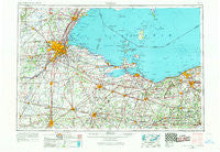
~ Toledo OH topo map, 1:250000 scale, 1 X 2 Degree, Historical, 1956, updated 1968
Toledo, Ohio, USGS topographic map dated 1956.
Includes geographic coordinates (latitude and longitude). This topographic map is suitable for hiking, camping, and exploring, or framing it as a wall map.
Printed on-demand using high resolution imagery, on heavy weight and acid free paper, or alternatively on a variety of synthetic materials.
Topos available on paper, Waterproof, Poly, or Tyvek. Usually shipping rolled, unless combined with other folded maps in one order.
- Product Number: USGS-5321602
- Free digital map download (high-resolution, GeoPDF): Toledo, Ohio (file size: 12 MB)
- Map Size: please refer to the dimensions of the GeoPDF map above
- Weight (paper map): ca. 55 grams
- Map Type: POD USGS Topographic Map
- Map Series: HTMC
- Map Verison: Historical
- Cell ID: 69054
- Scan ID: 226805
- Imprint Year: 1968
- Woodland Tint: Yes
- Edit Year: 1967
- Field Check Year: 1956
- Datum: Unstated
- Map Projection: Transverse Mercator
- Map published by United States Geological Survey
- Map published by United States Army Corps of Engineers
- Map published by United States Army
- Map Language: English
- Scanner Resolution: 600 dpi
- Map Cell Name: Toledo
- Grid size: 1 X 2 Degree
- Date on map: 1956
- Map Scale: 1:250000
- Geographical region: Ohio, United States
Neighboring Maps:
All neighboring USGS topo maps are available for sale online at a variety of scales.
Spatial coverage:
Topo map Toledo, Ohio, covers the geographical area associated the following places:
- New Rochester - Grand Rapids - Metamora - Business Corner - Perrysburg Heights - Scotch Ridge - Lorain - Holiday Estates - Sandburr Corners - Eagleville - Stony Ridge - Havens - Belmore - Twin Lakes Homes - York - Miltonville (historical) - West Independence - Frenchtown - Clinton Mobile Home Court - Rollersville - Maple Grove - Berch Terrace Mobile Home Park - Oakmont - Flechtner Heights - Ida Center - Omar - Amsden - Bloomingville - Gibsonburg Junction (historical) - Five Points - Leslie (historical) - New London - Alexis Addition - Pine Villas - Samaria - Rockaway - Oakridge Estates Mobile Home Park - Clarksfield - Alvada - Woodland Forest - Perrysburg - Booth - Harbor View - Mill Mobile Home Park - Squires - Gem Beach - Bayshore Estates Mobile Home Park - Ironville - Haven Park - Tousaint (historical) - Eastpointe on the Mall - D'Arcy Estates - Estral Beach - Grodis Corner - Castalia - Village Green Mobile Home Park - Friendly Village II Mobile Home Park - Nova - Fremont - North Baltimore - Immergrun - Updyke Addition - Baywater Estates - East Toledo - Coble Village - Termway Trailer Court - Kelleys Island - Linwood Court Mobile Home Park - Blissfield - Kansas - Gypsy Lane Estates Mobile Home Park - La Salle - Cooper - Milan - Sandusky - Hartland Station - Shannon - Townline (historical) - Auburndale - Avon Point - Crissey - Latcha - Erie West Mobile Home Park - Amherst - Eastowne Mobile Home Estates - Vacationland Mobile Home Park - Tinney - Celeryville - Birmingham - Wilkins - The Estates of Fort Meigs - Helena - Homer - Waterville - Bluebird Beach - Newtons (historical) - Garden - Mobile Home Estates - Midway - Center
- Map Area ID: AREA4241-84-82
- Northwest corner Lat/Long code: USGSNW42-84
- Northeast corner Lat/Long code: USGSNE42-82
- Southwest corner Lat/Long code: USGSSW41-84
- Southeast corner Lat/Long code: USGSSE41-82
- Northern map edge Latitude: 42
- Southern map edge Latitude: 41
- Western map edge Longitude: -84
- Eastern map edge Longitude: -82


