
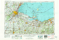
~ Toledo OH topo map, 1:250000 scale, 1 X 2 Degree, Historical, 1961, updated 1961
Toledo, Ohio, USGS topographic map dated 1961.
Includes geographic coordinates (latitude and longitude). This topographic map is suitable for hiking, camping, and exploring, or framing it as a wall map.
Printed on-demand using high resolution imagery, on heavy weight and acid free paper, or alternatively on a variety of synthetic materials.
Topos available on paper, Waterproof, Poly, or Tyvek. Usually shipping rolled, unless combined with other folded maps in one order.
- Product Number: USGS-5321600
- Free digital map download (high-resolution, GeoPDF): Toledo, Ohio (file size: 14 MB)
- Map Size: please refer to the dimensions of the GeoPDF map above
- Weight (paper map): ca. 55 grams
- Map Type: POD USGS Topographic Map
- Map Series: HTMC
- Map Verison: Historical
- Cell ID: 69054
- Scan ID: 226802
- Imprint Year: 1961
- Woodland Tint: Yes
- Field Check Year: 1956
- Datum: Unstated
- Map Projection: Transverse Mercator
- Map published by United States Geological Survey
- Map published by United States Army Corps of Engineers
- Map published by United States Army
- Map Language: English
- Scanner Resolution: 600 dpi
- Map Cell Name: Toledo
- Grid size: 1 X 2 Degree
- Date on map: 1961
- Map Scale: 1:250000
- Geographical region: Ohio, United States
Neighboring Maps:
All neighboring USGS topo maps are available for sale online at a variety of scales.
Spatial coverage:
Topo map Toledo, Ohio, covers the geographical area associated the following places:
- Attica Junction - Heidelberg Beach - Bayer Trailer Court - Gould - Chateau Estates - Pawnee - Shannon - Clearview Mobile Park - Shiperd Circle - Beulah Beach - Raisin Ridge Estate and Mobile Home Park - Young's Colonial Acres - Luna Pier - York - Lakeside - Palmyra - Northtown Meadows Mobile Home Park - Trilby - Wilmer - Woodhurst - Five Points - Glenwood - Asbury Hills - Cedar Tree Estates - Northridge Estates - Northgate - Champion - Amherst - Branchwood Estates - Neapolis - Omar - Townline (historical) - Foxborough - Rocky Ridge - Squires - Oberlin Beach - Deer Ridge Mobile Home Park - Diann - Avalon Beach - Crane Creek Place - Kansas - Raisin Center - Highland Estates - Orchard View - Isle Saint George - Findlay - Sylvania - Roachton - Colton - Williston - Tondagamies Village (historical) - Esselburn - Bloomingville - Folger (historical) - Oak Harbor - Saint Anthony - Monclova - Elliston - Raker Corners - Linwood Court Mobile Home Park - South Delta - Country Manor Estates - Mellwood - Portland Court - West Monroe - Elmore - Orchard Lane Trailer Court - Texas - Southview Estates Mobile Home Park - Reno Beach - Ballville - Lewisville (historical) - West Lodi - Lytton - Grape - Apollo Mobile Home Park - Ranch Wood - Twin Lakes Homes - Shoreway Mobile Home Park - Avery - The Estates of Fort Meigs - Pheasant Run Village - Brighton - Hille Farms - Angus - West Independence - Elyria - Erie - Scipio - Woodside - Prout (historical) - Cedar Point - Van Buren - Key Estates - Ironville - Eagleville - Cresceus Farms - Ranch Gardens - Saint Nicholas (historical) - Prentice (historical)
- Map Area ID: AREA4241-84-82
- Northwest corner Lat/Long code: USGSNW42-84
- Northeast corner Lat/Long code: USGSNE42-82
- Southwest corner Lat/Long code: USGSSW41-84
- Southeast corner Lat/Long code: USGSSE41-82
- Northern map edge Latitude: 42
- Southern map edge Latitude: 41
- Western map edge Longitude: -84
- Eastern map edge Longitude: -82


