
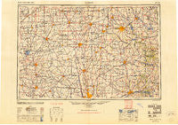
~ Marion OH topo map, 1:250000 scale, 1 X 2 Degree, Historical, 1950, updated 1950
Marion, Ohio, USGS topographic map dated 1950.
Includes geographic coordinates (latitude and longitude). This topographic map is suitable for hiking, camping, and exploring, or framing it as a wall map.
Printed on-demand using high resolution imagery, on heavy weight and acid free paper, or alternatively on a variety of synthetic materials.
Topos available on paper, Waterproof, Poly, or Tyvek. Usually shipping rolled, unless combined with other folded maps in one order.
- Product Number: USGS-5321590
- Free digital map download (high-resolution, GeoPDF): Marion, Ohio (file size: 14 MB)
- Map Size: please refer to the dimensions of the GeoPDF map above
- Weight (paper map): ca. 55 grams
- Map Type: POD USGS Topographic Map
- Map Series: HTMC
- Map Verison: Historical
- Cell ID: 75002
- Scan ID: 225742
- Imprint Year: 1950
- Woodland Tint: Yes
- Aerial Photo Year: 1944
- Datum: NAD27
- Map Projection: Transverse Mercator
- Map published by United States Geological Survey
- Map published by United States Army Corps of Engineers
- Map published by United States Army
- Map Language: English
- Scanner Resolution: 600 dpi
- Map Cell Name: Marion
- Grid size: 1 X 2 Degree
- Date on map: 1950
- Map Scale: 1:250000
- Geographical region: Ohio, United States
Neighboring Maps:
All neighboring USGS topo maps are available for sale online at a variety of scales.
Spatial coverage:
Topo map Marion, Ohio, covers the geographical area associated the following places:
- Welcome - Idlewood Cottage Area - Stewart (historical) - Heath - Upper Sandusky - Tiverton Center - Hampton Reserve - Marne - Macochee Castle - Pratts - Butler - Lamb Corners - Fleaville (historical) - Fort Fizzle - North Woodbury - Winnemac (historical) - Ralph (historical) - Tunnel Hill - Central College - Brownstown - Klondike - Highlands of Marion - Meadowbrook Mobile Home Park - Clivdon Mews - Albion - Village At North Falls - South Park - Frazeysburg - Rowsburg - Bloomfield - Orange - Davidson Run - Bryar - The Ravine - Lakeville - Avondale - Johnstown - North Lewisburg - Shire Cove - Mount Cory - Carrothers - Wooster Heights - Granville - Loudonville - Steam Corners - Bailey Lake - Huntsville - Mount Liberty - Walnut Grove - Waggoner Chase - Sparta - Harbor Pointe - Bowsherville (historical) - Creekstone - Owl Town (historical) - Pfeiffer - Dialton - Westerville - Ovid - Hickory Woods - Crystal Lakes - Sandy Corners - Alger - Green (historical) - Amity - Lovell - Crimson - Pattons Corners - Wammes Mobile Home Park - Union Station - South Peninsula Cottage Area - Heather Ridge - North Mount Vernon - Rosewood - Urbana - Hastings - Central Mobile Home Park - Fairview Mobile Home Park - Climax - Lexington - Crimville (historical) - Buxton Meadows - Spring Lake Village - Pagetown - Walnut Creek - Shady Lane Mobile Home Park - Bellefontaine - Academia - Zanesfield - Wilkins Run - Frampton - Spunky Puddle (historical) - West Bedford - Scioto Village - Westbriar - Lynn - Dola - Powell - Big Springs - Pulaskiville
- Map Area ID: AREA4140-84-82
- Northwest corner Lat/Long code: USGSNW41-84
- Northeast corner Lat/Long code: USGSNE41-82
- Southwest corner Lat/Long code: USGSSW40-84
- Southeast corner Lat/Long code: USGSSE40-82
- Northern map edge Latitude: 41
- Southern map edge Latitude: 40
- Western map edge Longitude: -84
- Eastern map edge Longitude: -82


