
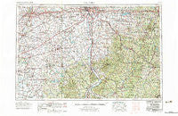
~ Columbus OH topo map, 1:250000 scale, 1 X 2 Degree, Historical, 1967, updated 1977
Columbus, Ohio, USGS topographic map dated 1967.
Includes geographic coordinates (latitude and longitude). This topographic map is suitable for hiking, camping, and exploring, or framing it as a wall map.
Printed on-demand using high resolution imagery, on heavy weight and acid free paper, or alternatively on a variety of synthetic materials.
Topos available on paper, Waterproof, Poly, or Tyvek. Usually shipping rolled, unless combined with other folded maps in one order.
- Product Number: USGS-5321588
- Free digital map download (high-resolution, GeoPDF): Columbus, Ohio (file size: 19 MB)
- Map Size: please refer to the dimensions of the GeoPDF map above
- Weight (paper map): ca. 55 grams
- Map Type: POD USGS Topographic Map
- Map Series: HTMC
- Map Verison: Historical
- Cell ID: 68727
- Scan ID: 224524
- Imprint Year: 1977
- Woodland Tint: Yes
- Visual Version Number: 1
- Aerial Photo Year: 1960
- Field Check Year: 1967
- Survey Year: 1966
- Datum: Unstated
- Map Projection: Transverse Mercator
- Map published by United States Geological Survey
- Map Language: English
- Scanner Resolution: 600 dpi
- Map Cell Name: Columbus
- Grid size: 1 X 2 Degree
- Date on map: 1967
- Map Scale: 1:250000
- Geographical region: Ohio, United States
Neighboring Maps:
All neighboring USGS topo maps are available for sale online at a variety of scales.
Spatial coverage:
Topo map Columbus, Ohio, covers the geographical area associated the following places:
- Village At Shannon Green - Jimtown - Mooresville - Rehoboth - Donnelsville - Crabill Road Farms - Hills (historical) - Coon Crossing - Adelphi - Meadow Grove East - Summerlyn - Licking View - Greenland - Mechanicsville (historical) - Southgate - Brookside Park Mobile Home Park - Harding Heights - Emerald Pines Mobile Home Park - Suburban Village - Mount Pleasant - Dexter - Zaleski - Starr - Ilesboro - Harrisonville - South Perry - Bannon - New Salem - Clifton - Yatesville - Shrine Road Mobile Home Park - Belmont Meadows - Williamsport - Union Furnace - Alkire Village - South Logan - Harris - Royalton - Upper Fivemile - Gunnerville - Byington - Seymoreville (historical) - South Vienna - Wolfpen - Morristown - Oakfield - Wonder Hills - Brocks Corner - Portersville - Atherton - Buckhorn (historical) - Grove City Country Club - Olbers - Eastburn (historical) - Mulga - Bardwell - Pine Grove Heights - Hamden - Arbaugh - Five Points - Lees Creek - Sun Set Mobile Home Park - Minnehan Bend - Lewis (historical) - Hennessey (historical) - Happy Homes - Woodlyn - Monday Creek Junction - Lincolnville - Higby - Candy Town - Wyandotte (historical) - Rose Hill Heights - Cunningham - Wesley Chapel - Chenoweth - Thornville - Bainbridge - Ural (historical) - J D Smith Mobile Home Park - Brighton - Cedar Falls (historical) - Carthon - Thrifton - Brandon Court - Geneva - Bloomington - Pinewood Village - Pherson - The Plains - Givens - Hanford - Deems (historical) - Fairfield Beach - Quaker Hill - Oakland - Baltimore - Dillon View - Red Diamond - Hollywood by the Lake
- Map Area ID: AREA4039-84-82
- Northwest corner Lat/Long code: USGSNW40-84
- Northeast corner Lat/Long code: USGSNE40-82
- Southwest corner Lat/Long code: USGSSW39-84
- Southeast corner Lat/Long code: USGSSE39-82
- Northern map edge Latitude: 40
- Southern map edge Latitude: 39
- Western map edge Longitude: -84
- Eastern map edge Longitude: -82


