
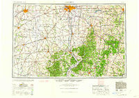
~ Columbus OH topo map, 1:250000 scale, 1 X 2 Degree, Historical, 1962, updated 1962
Columbus, Ohio, USGS topographic map dated 1962.
Includes geographic coordinates (latitude and longitude). This topographic map is suitable for hiking, camping, and exploring, or framing it as a wall map.
Printed on-demand using high resolution imagery, on heavy weight and acid free paper, or alternatively on a variety of synthetic materials.
Topos available on paper, Waterproof, Poly, or Tyvek. Usually shipping rolled, unless combined with other folded maps in one order.
- Product Number: USGS-5321584
- Free digital map download (high-resolution, GeoPDF): Columbus, Ohio (file size: 15 MB)
- Map Size: please refer to the dimensions of the GeoPDF map above
- Weight (paper map): ca. 55 grams
- Map Type: POD USGS Topographic Map
- Map Series: HTMC
- Map Verison: Historical
- Cell ID: 68727
- Scan ID: 224521
- Imprint Year: 1962
- Woodland Tint: Yes
- Aerial Photo Year: 1940
- Datum: Unstated
- Map Projection: Transverse Mercator
- Map published by United States Geological Survey
- Map published by United States Army Corps of Engineers
- Map published by United States Army
- Map Language: English
- Scanner Resolution: 600 dpi
- Map Cell Name: Columbus
- Grid size: 1 X 2 Degree
- Date on map: 1962
- Map Scale: 1:250000
- Geographical region: Ohio, United States
Neighboring Maps:
All neighboring USGS topo maps are available for sale online at a variety of scales.
Spatial coverage:
Topo map Columbus, Ohio, covers the geographical area associated the following places:
- Happy Homes - Monroe - Matville - Sand Run Junction - Rock Mills - Sulphur Springs - Grove City Country Club - Robbins (historical) - Sheldon (historical) - Markley (historical) - Silver Springs - Miller (historical) - Edgewater Park - Mayfair Park - Great Oak - Chillicothe - Stringtown - Rehm - Pursell (historical) - Midland - Denver - Moxahala - Goosetown (historical) - Oakland - Brownstown (historical) - Hallsville - Plumwood Mobile Home Park - Possum Woods - Keller Farm - West Grove - Melvin - Big Walnut (historical) - Westbend - Vauces - Old Gore - Elizabeth - Dorney (historical) - West Jefferson - Valley Crossing - Clifton - Thornport - Linnville - Canal Winchester - Sligo - McArthur - Lake White Mobile Home Park - Highlander Trailer Park - Madison Lake - Avalon Heights - Clifton - Ziontown - Wilson (historical) - Washington Meadows - Belleview Heights - Big Rock - Glencoe Estates - Longview Heights - Pageville - Gist Settlement - Eastmoor Subdivision - Glen Jean - Circle Hills - Portersville - Havensport - Chevington Woods North - Richmond Dale - White Oak - Pricetown - Dumontville - New Floodwood - Kensington Glen - New Lexington - Jackson - Stringtown - Beachwood Lake Estates - Timberbrook - Barfield Heights - Green Acres - Drakes - Carbondale - Villa - Arbaugh - Grooms - Grove City Heights - Brookgrove - Charleston (historical) - Fairview - Bloomingburg Mobile Home Park - Consol (historical) - Fairfield Farms - Darlington - Valley View - Daleyville - Straitsville - Houck Meadows - Brookside Park Mobile Home Park - Humboldt - Three Locks - Alkire Village - Jessup
- Map Area ID: AREA4039-84-82
- Northwest corner Lat/Long code: USGSNW40-84
- Northeast corner Lat/Long code: USGSNE40-82
- Southwest corner Lat/Long code: USGSSW39-84
- Southeast corner Lat/Long code: USGSSE39-82
- Northern map edge Latitude: 40
- Southern map edge Latitude: 39
- Western map edge Longitude: -84
- Eastern map edge Longitude: -82


