
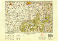
~ Columbus OH topo map, 1:250000 scale, 1 X 2 Degree, Historical, 1947, updated 1948
Columbus, Ohio, USGS topographic map dated 1947.
Includes geographic coordinates (latitude and longitude). This topographic map is suitable for hiking, camping, and exploring, or framing it as a wall map.
Printed on-demand using high resolution imagery, on heavy weight and acid free paper, or alternatively on a variety of synthetic materials.
Topos available on paper, Waterproof, Poly, or Tyvek. Usually shipping rolled, unless combined with other folded maps in one order.
- Product Number: USGS-5321580
- Free digital map download (high-resolution, GeoPDF): Columbus, Ohio (file size: 16 MB)
- Map Size: please refer to the dimensions of the GeoPDF map above
- Weight (paper map): ca. 55 grams
- Map Type: POD USGS Topographic Map
- Map Series: HTMC
- Map Verison: Historical
- Cell ID: 68727
- Scan ID: 224518
- Imprint Year: 1948
- Woodland Tint: Yes
- Aerial Photo Year: 1940
- Datum: NAD27
- Map Projection: Transverse Mercator
- Map published by United States Geological Survey
- Map published by United States Army Corps of Engineers
- Map published by United States Army
- Map Language: English
- Scanner Resolution: 600 dpi
- Map Cell Name: Columbus
- Grid size: 1 X 2 Degree
- Date on map: 1947
- Map Scale: 1:250000
- Geographical region: Ohio, United States
Neighboring Maps:
All neighboring USGS topo maps are available for sale online at a variety of scales.
Spatial coverage:
Topo map Columbus, Ohio, covers the geographical area associated the following places:
- Andersonville - Carvel Manor Mobile Home Park - Point Pleasant (historical) - San Toy - Lisbon - Radcliff - Yankeetown - Essex Place - Davisville - New Strasburg - Brookside Park - Saint Martin - Clarion - Chillicothe - Logan Elm Village - Thorps - Pleasant Corners - Moores Junction - Beckley Addition - Alice - Riceville (historical) - Allensville - Kinderhook - Glencoe Estates - Clearview - East Columbus - Vandervorts Corners - Wesley - Babingtons Trailer Park - Meadow Lane - The Villages At Winchester - Beaver Pike Estates - Elmhurst - Cheviot Hills - Altoona - Zeal (historical) - Concord Park - Avondale - Fairview - Byington - New Lexington - Lindair Acres - Brookside Park - Hennessey (historical) - Fairview - McKendree - Pickerington - Bryson (historical) - Millfield - Highlander Trailer Park - Jackson Heights - Lumberton - Mount Perry - Barretts Mills - Bristol - Johnson - Bradbury - Minnehan Bend - Taylor Mobile Home Park - Massieville - Happy Valley Mobile Home Park - Point Rock - Cawthorn - Emerald Pines Mobile Home Park - Brownstown (historical) - Somerset - South Bloomingville - Glade - Morristown - Enterprise - Fruitdale - Linnville - Tropic - Oreville - Paintersville - Grove City Heights - Post Oak Country Estates - Dyesville - Grooms - Range - Port William - Harbor Hills - Hemlock - White's Mobile Home Park - South Bloomfield - Rock Way - Mount Sinai - Creekside - Valley View - Claybank (historical) - Lithopolis - Alkire Village - Siverly - Epernay - Summithill - Village At Shannon Green - Starr - Marble Cliff - Monterey Park - Kingston
- Map Area ID: AREA4039-84-82
- Northwest corner Lat/Long code: USGSNW40-84
- Northeast corner Lat/Long code: USGSNE40-82
- Southwest corner Lat/Long code: USGSSW39-84
- Southeast corner Lat/Long code: USGSSE39-82
- Northern map edge Latitude: 40
- Southern map edge Latitude: 39
- Western map edge Longitude: -84
- Eastern map edge Longitude: -82


