
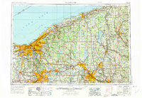
~ Cleveland OH topo map, 1:250000 scale, 1 X 2 Degree, Historical, 1956, updated 1975
Cleveland, Ohio, USGS topographic map dated 1956.
Includes geographic coordinates (latitude and longitude). This topographic map is suitable for hiking, camping, and exploring, or framing it as a wall map.
Printed on-demand using high resolution imagery, on heavy weight and acid free paper, or alternatively on a variety of synthetic materials.
Topos available on paper, Waterproof, Poly, or Tyvek. Usually shipping rolled, unless combined with other folded maps in one order.
- Product Number: USGS-5321576
- Free digital map download (high-resolution, GeoPDF): Cleveland, Ohio (file size: 19 MB)
- Map Size: please refer to the dimensions of the GeoPDF map above
- Weight (paper map): ca. 55 grams
- Map Type: POD USGS Topographic Map
- Map Series: HTMC
- Map Verison: Historical
- Cell ID: 68719
- Scan ID: 224484
- Imprint Year: 1975
- Woodland Tint: Yes
- Aerial Photo Year: 1972
- Edit Year: 1972
- Field Check Year: 1956
- Datum: Unstated
- Map Projection: Transverse Mercator
- Map published by United States Geological Survey
- Map published by: Military, Other
- Map Language: English
- Scanner Resolution: 600 dpi
- Map Cell Name: Cleveland
- Grid size: 1 X 2 Degree
- Date on map: 1956
- Map Scale: 1:250000
- Geographical region: Ohio, United States
Neighboring Maps:
All neighboring USGS topo maps are available for sale online at a variety of scales.
Spatial coverage:
Topo map Cleveland, Ohio, covers the geographical area associated the following places:
- Frank's Mobile Home Park - Camp Park - Remsen Corners - Johnson Mobile Home Park - Poland - Maderite Heights - Braceville - Berkeley - Pebblebrook - West Hill - Windsor Mills - Linndale - Six Corners - Clarks - Lobaugh - Eagleville - Midway Trailer Court - Iron Bridge (historical) - Goodyear Heights - Clifton Park - Echo Lake Glen - Windham - Carter - Padanaram - West Steels Corners - Sunset Mobile Home Park - Jacques High Chapparal Mobile Home Park - Warrensville - Grove City - Herner Corners - West Springfield - Southwood Colony - Five Points - Beardsley (historical) - Country Club Estates - Moreland Hills - New Wilmington - Germantown (historical) - Mobile Haven Park - Middleboro - McDonald - West Ridge - Countrywide Estates - Moran - Robinson - North Linndale - Enterprise - Redmond - Steamburg - Furnace Hill - Fairview - Cranmer - Libby Aurora Mobile Home Park - Enterprise (historical) - Hedgewood - Pinney Corners - Farmington Place - Kyles Corners - Five Points - Salow Corners - Acme - Boal's Trailer Park - Richfield Heights - Birds Nest - Kantz Corners - Mercer - Bettes Corners - Breakman - Sunset Valley - Kerrington Estates - Mountain View - Schofield Corners - Pleasant Park Mobile Home Park - Paynes Corner - Spring - Bosworth (historical) - Smith Corners - Stoney Hill - Bath - Copley Junction - Black Horse - Center Corner - Summit Beach Park - Turner - Mobile Acres - Reeds Furnace - McLane - Lakeview Terrace - Mayfield - Garrettsville - Drakesburg - Fredericksburg - Coddingville - Westhill Estates - Orange Center - Victoria Estates - Transfer - Saint Joseph - Chagrin Harbor - Hidden Cove Mobile Home Park
- Map Area ID: AREA4241-82-80
- Northwest corner Lat/Long code: USGSNW42-82
- Northeast corner Lat/Long code: USGSNE42-80
- Southwest corner Lat/Long code: USGSSW41-82
- Southeast corner Lat/Long code: USGSSE41-80
- Northern map edge Latitude: 42
- Southern map edge Latitude: 41
- Western map edge Longitude: -82
- Eastern map edge Longitude: -80


