
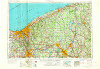
~ Cleveland OH topo map, 1:250000 scale, 1 X 2 Degree, Historical, 1956, updated 1967
Cleveland, Ohio, USGS topographic map dated 1956.
Includes geographic coordinates (latitude and longitude). This topographic map is suitable for hiking, camping, and exploring, or framing it as a wall map.
Printed on-demand using high resolution imagery, on heavy weight and acid free paper, or alternatively on a variety of synthetic materials.
Topos available on paper, Waterproof, Poly, or Tyvek. Usually shipping rolled, unless combined with other folded maps in one order.
- Product Number: USGS-5321574
- Free digital map download (high-resolution, GeoPDF): Cleveland, Ohio (file size: 17 MB)
- Map Size: please refer to the dimensions of the GeoPDF map above
- Weight (paper map): ca. 55 grams
- Map Type: POD USGS Topographic Map
- Map Series: HTMC
- Map Verison: Historical
- Cell ID: 68719
- Scan ID: 224483
- Imprint Year: 1967
- Woodland Tint: Yes
- Edit Year: 1966
- Field Check Year: 1956
- Datum: Unstated
- Map Projection: Transverse Mercator
- Map published by United States Geological Survey
- Map published by United States Army Corps of Engineers
- Map published by United States Army
- Map Language: English
- Scanner Resolution: 600 dpi
- Map Cell Name: Cleveland
- Grid size: 1 X 2 Degree
- Date on map: 1956
- Map Scale: 1:250000
- Geographical region: Ohio, United States
Neighboring Maps:
All neighboring USGS topo maps are available for sale online at a variety of scales.
Spatial coverage:
Topo map Cleveland, Ohio, covers the geographical area associated the following places:
- Kyles Corners - Valleyview Homes (historical) - Drake - Bristolville - East Claridon - New Wilmington - South Akron - Greenleafs Corners (historical) - Brook Park Mobile Home Park - Bobbys Corners - Brecksville - Carter - Rocky River - Troy Oaks Homes - Chagrin Harbor - Duck Creek - East Ashtabula - Leader's Mobile Home Park - Briarwood Beach - Reeds Corners - Roseland - Conneaut - Warren - Century Bay - Shamrock Trailer Park - Salida - Summit Mobile Home Park - Ellsworth - Dlworth - Camp Roosevelt - Poland Center - Charlestown - Taylor Corners - The Estates - Bulah - Willowick - Brent - Hiram Rapids - Cudell - Holdlen Hills - Harlansburg - Bretton Woods - Pritchard - Skeltontown - Lakemore - Forest Park - Smith Corners - Sodom - Clarks - Big Bend - Herbert Corners - Starrs Corners - State Road - South Denmark - Copley Junction - Westwood Farms - North Bristol - Wilder Senior Citizen Mobile Home Park North - Tallmadge - Rays Corners - Leon - Conneaut Lake - Hunting Valley - Brier Hill - Fish Creek - Thompson - Metz - Stoneboro - Suburban Mobile Home Park - Hilltown (historical) - Fairmount - Lobaugh - Mecca - Belmar Park - Center Road (historical) - Yale - Cranesville - Jacques High Chapparal Mobile Home Park - Chester Center - McCoytown - Hells Corners - Brooklyn Acres - McKays Corners - Chagrin Falls - Oak Hill Village - Evergreen Mobile Home Court - Kerrington Estates - Hillsville - Miller Mobile Homes - Queens Court - Mentor Acres - Freedom Dam - Monroe Center - Rolling Wheel Park - Parkland - West Liberty - Rundell - Huntsburg - Keans (historical) - Ravenna
- Map Area ID: AREA4241-82-80
- Northwest corner Lat/Long code: USGSNW42-82
- Northeast corner Lat/Long code: USGSNE42-80
- Southwest corner Lat/Long code: USGSSW41-82
- Southeast corner Lat/Long code: USGSSE41-80
- Northern map edge Latitude: 42
- Southern map edge Latitude: 41
- Western map edge Longitude: -82
- Eastern map edge Longitude: -80


