
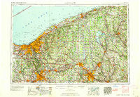
~ Cleveland OH topo map, 1:250000 scale, 1 X 2 Degree, Historical, 1962
Cleveland, Ohio, USGS topographic map dated 1962.
Includes geographic coordinates (latitude and longitude). This topographic map is suitable for hiking, camping, and exploring, or framing it as a wall map.
Printed on-demand using high resolution imagery, on heavy weight and acid free paper, or alternatively on a variety of synthetic materials.
Topos available on paper, Waterproof, Poly, or Tyvek. Usually shipping rolled, unless combined with other folded maps in one order.
- Product Number: USGS-5321572
- Free digital map download (high-resolution, GeoPDF): Cleveland, Ohio (file size: 17 MB)
- Map Size: please refer to the dimensions of the GeoPDF map above
- Weight (paper map): ca. 55 grams
- Map Type: POD USGS Topographic Map
- Map Series: HTMC
- Map Verison: Historical
- Cell ID: 68719
- Scan ID: 224482
- Woodland Tint: Yes
- Field Check Year: 1956
- Datum: Unstated
- Map Projection: Transverse Mercator
- Map published by United States Geological Survey
- Map published by United States Army Corps of Engineers
- Map published by United States Army
- Map Language: English
- Scanner Resolution: 600 dpi
- Map Cell Name: Cleveland
- Grid size: 1 X 2 Degree
- Date on map: 1962
- Map Scale: 1:250000
- Geographical region: Ohio, United States
Neighboring Maps:
All neighboring USGS topo maps are available for sale online at a variety of scales.
Spatial coverage:
Topo map Cleveland, Ohio, covers the geographical area associated the following places:
- Swartz Corners - Yankee Lake - Westwood Lake Park - Onspaugh Corners - Broadview Heights - Grimms Mobile Home Park - Westpark - Courtland Meadows - DeForest - Paynes Corner - Carmona - Oak Hill Mobile Home Park - Kyles Corners - Johnson Mobile Home Park - White House Park - Pont - Will-O-Wick - Ideal Mobile Home Park - West Walnut Estates - Olmsted - Niles Junction - Doughertys Mills - Beaver Center - Noble - Moran - Chapel - Tuttle Lake - Peanut - Somerset 45 Manor - Meadville Junction - East Trumbull - Point West - Pageville - Geneva - Everett - Will-O-Way Beach - Stony Point - Barberton - Lloyd - Shaws Corners - Mecca - Sandy Lake - Briarwood Beach - Courtneys Mills - Youngstown - Kerrtown - Mayfield Heights - South Brooklyn - Delamater Corners - Stoney Hill - Lakeville - Forest Grove Mobile Home Park - Newport (historical) - Melrose - Edinboro - Boston - Lake Milton - Lakeside Terrace - Parma Heights - Bostwick - Westhill Heights - Villa Maria - Kingsville - Carter - Maysville - Golfway Pines - Northfield Center - Industry - Clarks Mills - Dowley Corners - Evergreen Mobile Home Court - Meadow Lane - Independence - Mesopotamia - Hermitage - Hope Mills - Lundys Lane - Parkman - Birds Nest - Profeta's Mobile Home Park - Five Corners - Middleburg Heights - Westlake - Plymouth Center - New Lyme Station - Yankee Hills - Auburn Corners - Auburn Center - North Dover - Slavic Village - Wheatland - Petroleum - Lyle - Willowick - Smith Corners - Harbor - The Angle - McCoytown - Bement - Streetsboro
- Map Area ID: AREA4241-82-80
- Northwest corner Lat/Long code: USGSNW42-82
- Northeast corner Lat/Long code: USGSNE42-80
- Southwest corner Lat/Long code: USGSSW41-82
- Southeast corner Lat/Long code: USGSSE41-80
- Northern map edge Latitude: 42
- Southern map edge Latitude: 41
- Western map edge Longitude: -82
- Eastern map edge Longitude: -80


