
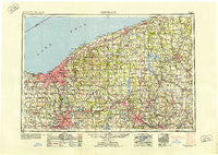
~ Cleveland OH topo map, 1:250000 scale, 1 X 2 Degree, Historical, 1950
Cleveland, Ohio, USGS topographic map dated 1950.
Includes geographic coordinates (latitude and longitude). This topographic map is suitable for hiking, camping, and exploring, or framing it as a wall map.
Printed on-demand using high resolution imagery, on heavy weight and acid free paper, or alternatively on a variety of synthetic materials.
Topos available on paper, Waterproof, Poly, or Tyvek. Usually shipping rolled, unless combined with other folded maps in one order.
- Product Number: USGS-5321570
- Free digital map download (high-resolution, GeoPDF): Cleveland, Ohio (file size: 17 MB)
- Map Size: please refer to the dimensions of the GeoPDF map above
- Weight (paper map): ca. 55 grams
- Map Type: POD USGS Topographic Map
- Map Series: HTMC
- Map Verison: Historical
- Cell ID: 68719
- Scan ID: 224478
- Woodland Tint: Yes
- Aerial Photo Year: 1944
- Datum: NAD27
- Map Projection: Transverse Mercator
- Map published by United States Geological Survey
- Map published by United States Army Corps of Engineers
- Map published by United States Army
- Map Language: English
- Scanner Resolution: 600 dpi
- Map Cell Name: Cleveland
- Grid size: 1 X 2 Degree
- Date on map: 1950
- Map Scale: 1:250000
- Geographical region: Ohio, United States
Neighboring Maps:
All neighboring USGS topo maps are available for sale online at a variety of scales.
Spatial coverage:
Topo map Cleveland, Ohio, covers the geographical area associated the following places:
- Little Mountain - Davis - Hillsville - Purdys Trailer Park - Avalon Estates - Geauga Lake - Cotswold Manor - Sheakleyville - Brooklyn Heights - Woodhill Homes - Rockport - East Farmington - Stroups - Madden Corners - Tallmadge - Brookside Park - Evergreen Village - Tiger - Delamater Corners - Denmark Center - Highland Heights - Cornelion - Antietam (historical) - Walnut Hill (historical) - Edgewood Mobile Home Park - Hendersonville - Applecreek Village - Brookdale Mobile Home Park - Ideal Mobile Home Park - Stony Point - Edinboro - Glenville - Perry - Lake Park Estates - Prestwick Glen - Schollard - Tuttle Lake - Albion - Western Star - Arlington - Parma Heights - North Bristol - Booher Corners - Ollins Corners - Sugar Bush Knolls - Brier Hill - Firestone Park - Seville - Logtown - Jefferson Mobile Estates - North Solon - Poland - Five Corners - Fowlers Mill - Springlake Trailer Park - Onspaugh Corners - West Walnut Estates - Doverwood Estates - Briar Hill Corners - Villa Maria - North Richmond - Oakland - Darrowville - Rome - Bowie - Reeds Corners - Linesville - Burton - Five Corners - Beachwood - New Bedford - Cork - Bolindale - Maderite Heights - Dlworth - Lake Milton Mobile Home Park - Valley Hills - London - Turkey Foot Corner - Volant - P And M Estates - Madison Dock (historical) - Carmona - Swamproot (historical) - East Cleveland - Bentley (historical) - Sunol - Columbia Park - Gaslight Village Mobile Home Park - Four Seasons Mobile Home Park - Andersons Corner - Niles - Shepard's Mobile Home Park - Wheatland - Poznan - Saybrook-on-the-lake - Centertown - Granger - Woodcock Grange - South Niles
- Map Area ID: AREA4241-82-80
- Northwest corner Lat/Long code: USGSNW42-82
- Northeast corner Lat/Long code: USGSNE42-80
- Southwest corner Lat/Long code: USGSSW41-82
- Southeast corner Lat/Long code: USGSSE41-80
- Northern map edge Latitude: 42
- Southern map edge Latitude: 41
- Western map edge Longitude: -82
- Eastern map edge Longitude: -80


