
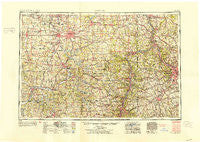
~ Canton OH topo map, 1:250000 scale, 1 X 2 Degree, Historical, 1953
Canton, Ohio, USGS topographic map dated 1953.
Includes geographic coordinates (latitude and longitude). This topographic map is suitable for hiking, camping, and exploring, or framing it as a wall map.
Printed on-demand using high resolution imagery, on heavy weight and acid free paper, or alternatively on a variety of synthetic materials.
Topos available on paper, Waterproof, Poly, or Tyvek. Usually shipping rolled, unless combined with other folded maps in one order.
- Product Number: USGS-5321560
- Free digital map download (high-resolution, GeoPDF): Canton, Ohio (file size: 19 MB)
- Map Size: please refer to the dimensions of the GeoPDF map above
- Weight (paper map): ca. 55 grams
- Map Type: POD USGS Topographic Map
- Map Series: HTMC
- Map Verison: Historical
- Cell ID: 68700
- Scan ID: 224319
- Woodland Tint: Yes
- Aerial Photo Year: 1943
- Datum: NAD27
- Map Projection: Transverse Mercator
- Map published by United States Army Corps of Engineers
- Map published by United States Army
- Map Language: English
- Scanner Resolution: 600 dpi
- Map Cell Name: Canton
- Grid size: 1 X 2 Degree
- Date on map: 1953
- Map Scale: 1:250000
- Geographical region: Ohio, United States
Neighboring Maps:
All neighboring USGS topo maps are available for sale online at a variety of scales.
Spatial coverage:
Topo map Canton, Ohio, covers the geographical area associated the following places:
- Gregg - Valley Glen - North Park - Tyrone - Fallston - Treveskyn - L And S Trailer Park - Zoar - Cadiz Junction - Moon - Eighty Four - Seven Fields - Black - Pleasantville (historical) - Dogtown (historical) - Mingo Junction - Damascus - McCance - Yellow Creek - Belleve - Moorefield - Roanoake - Grove Mill - Speidel - Fairoaks - McGarry (historical) - Maplecroft Mobile Home Park - Bellevue - Wurtemburg - Wheeling Valley (historical) - West Liberty - Linton Mills - Allison Park - Unity - Carnot - Duncanwood - Gambles - Shel Mar Mobile Home Park - Wellsville - Hemlock Green Estates - Guilford - Ten Mile - East Orchard - Cokeburg - Heidelberg - Chapman Addition - Groveton - Odell - Robertsville - Bon Air Estates - Altamont - Lake Sherman Village - Fredericktown Hill - Unionville - Parral - Colliers - Charleston Place - Plainsburg (historical) - Maple Rest Mobile Court - North Salem - Stone Creek - Hopewell - Coverdale - New Rumley - Beverly Hills - Mechanicsburg - Braddock - Turkeyfoot Heights - Art Smith Trailer Park - Willow Brook Heights - Battlesburg - Coverdale - Avalon - East New Castle - Fohl Village - Big Beaver - Germantown - Golda - West Liberty - Wolfes Mobile Home Park - Pleasant Grove - Belvedere - Highland Terrace - Harter Heights - Hillcrest - Benton - West Park - Finleyville - Serenity Shores - Petersville - Creekside Crossing - Wheeling Creek - Porters Corners - Brownsdale Mobile Home Park - Avondale - Finney - Rockford - Fairview - Hickory Corners - South Haven Mobile Park
- Map Area ID: AREA4140-82-80
- Northwest corner Lat/Long code: USGSNW41-82
- Northeast corner Lat/Long code: USGSNE41-80
- Southwest corner Lat/Long code: USGSSW40-82
- Southeast corner Lat/Long code: USGSSE40-80
- Northern map edge Latitude: 41
- Southern map edge Latitude: 40
- Western map edge Longitude: -82
- Eastern map edge Longitude: -80


