
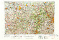
~ Canton OH topo map, 1:250000 scale, 1 X 2 Degree, Historical, 1962
Canton, Ohio, USGS topographic map dated 1962.
Includes geographic coordinates (latitude and longitude). This topographic map is suitable for hiking, camping, and exploring, or framing it as a wall map.
Printed on-demand using high resolution imagery, on heavy weight and acid free paper, or alternatively on a variety of synthetic materials.
Topos available on paper, Waterproof, Poly, or Tyvek. Usually shipping rolled, unless combined with other folded maps in one order.
- Product Number: USGS-5321556
- Free digital map download (high-resolution, GeoPDF): Canton, Ohio (file size: 21 MB)
- Map Size: please refer to the dimensions of the GeoPDF map above
- Weight (paper map): ca. 55 grams
- Map Type: POD USGS Topographic Map
- Map Series: HTMC
- Map Verison: Historical
- Cell ID: 68700
- Scan ID: 224317
- Woodland Tint: Yes
- Field Check Year: 1957
- Datum: Unstated
- Map Projection: Transverse Mercator
- Map published by United States Geological Survey
- Map Language: English
- Scanner Resolution: 600 dpi
- Map Cell Name: Canton
- Grid size: 1 X 2 Degree
- Date on map: 1962
- Map Scale: 1:250000
- Geographical region: Ohio, United States
Neighboring Maps:
All neighboring USGS topo maps are available for sale online at a variety of scales.
Spatial coverage:
Topo map Canton, Ohio, covers the geographical area associated the following places:
- East Carmel - Sippo - Stoney Creek Estates - Spruce Tree Village - Boydsville - Betty Zane - Highland Terrace - Mill Rock - Studa - Bridgewater - Enterprise - Beaver Street Trailer Court - Chambers Mill - Wheeling Heights - Ginger Hill - Columbia - Hazen - Good Intent - Enfield (historical) - Lake View Heights - Woodale Village Mobile Home Park - Jewett - Cherry Valley - Swickards Addition - Rea - Diamond (historical) - Morgan - Weems - Avella - West Wheeling - Woodville - Celia - Laurel Gardens - North Market Mobile Home Park - West Point - Logrow - Weircrest - Island - Rochester - Kennon (historical) - Sheraden - New Manchester - Bellton - Green Acres - Arrowhead - Pines Cottage Area - Deemston - Wheeling Creek - Irondale - North Sewickley - Ginther (historical) - Mount de Chantal - Oldham - Rockville - Windgap - State Line (historical) - New Salisbury - East Steubenville - Yankeetown (historical) - Dungannon - Estates At Meadow Wood - Barton Manor - Serenity Shores - Clinton - Smith Corners - Berlin - Bishop - South Strabane - Grant City - Vanport - Crossroads - Bon Meade - Vineyard Hills - Prosperity - Fredericktown - Lovi - New Beaver - New Middleton - Pinn (historical) - Sewickley Heights - Comet Trailer Park - Northgate - Grandview Heights - Sunshine Park - Montour Junction - Sandyville - Banetown - Town And Country Park Estates - Oakdale - Stone Creek - Wainwright - New Franklin - Beham - Economy - Glendale - East Greenville - Little Summit - Avondale - Clover Trailer Park - Gringo
- Map Area ID: AREA4140-82-80
- Northwest corner Lat/Long code: USGSNW41-82
- Northeast corner Lat/Long code: USGSNE41-80
- Southwest corner Lat/Long code: USGSSW40-82
- Southeast corner Lat/Long code: USGSSE40-80
- Northern map edge Latitude: 41
- Southern map edge Latitude: 40
- Western map edge Longitude: -82
- Eastern map edge Longitude: -80


