
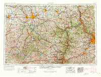
~ Canton OH topo map, 1:250000 scale, 1 X 2 Degree, Historical, 1957, updated 1971
Canton, Ohio, USGS topographic map dated 1957.
Includes geographic coordinates (latitude and longitude). This topographic map is suitable for hiking, camping, and exploring, or framing it as a wall map.
Printed on-demand using high resolution imagery, on heavy weight and acid free paper, or alternatively on a variety of synthetic materials.
Topos available on paper, Waterproof, Poly, or Tyvek. Usually shipping rolled, unless combined with other folded maps in one order.
- Product Number: USGS-5321554
- Free digital map download (high-resolution, GeoPDF): Canton, Ohio (file size: 22 MB)
- Map Size: please refer to the dimensions of the GeoPDF map above
- Weight (paper map): ca. 55 grams
- Map Type: POD USGS Topographic Map
- Map Series: HTMC
- Map Verison: Historical
- Cell ID: 68700
- Scan ID: 224316
- Imprint Year: 1971
- Woodland Tint: Yes
- Edit Year: 1969
- Field Check Year: 1957
- Datum: Unstated
- Map Projection: Transverse Mercator
- Map published by United States Geological Survey
- Map Language: English
- Scanner Resolution: 600 dpi
- Map Cell Name: Canton
- Grid size: 1 X 2 Degree
- Date on map: 1957
- Map Scale: 1:250000
- Geographical region: Ohio, United States
Neighboring Maps:
All neighboring USGS topo maps are available for sale online at a variety of scales.
Spatial coverage:
Topo map Canton, Ohio, covers the geographical area associated the following places:
- Lynn Center Park - North Fredericktown - Benwood - Peoli - Clearview - Cedar Hills - Millers Corners - Rockdale - Marlboro - New Harrisburg - Deardoffs Mills (historical) - Tabor - Scroggsfield - Toots Crossroads - Maximo - Willow Crest - Bowmans Corners - Startle (historical) - Cedar Rocks - Millheim - Washington Junction - West Fulton - Donley - Dutchtown - Skit - Mount Pleasant Estates - Crossroads - East Washington - Moravia - Pressler Heights - Sugar Grove - Patmos - Goodland Acres - Island Creek - Sunny Acres Mobile Park - Hillsboro - Strabane - Negley - Garfield - Newport - Ridgedale - Union Valley - Kungle Heights - The Highlands At Green - Portersville - Mantua - Deadmans (historical) - Independence - Allegheny Center - Dixmont - Dellroy - Morningview - Carrollton - Leatherwood - Beechwood Mobile Estates - Genoa - McKnight - Van Emman - Downieville - Middleburg - Osage - Carnegie - Pleasant Grove - Yeagleys Corners - Greentown - Sunset Valley - Fairview Heights - Lynn Mobile Manor - Lindentree - Beechview - Maddens (historical) - South Wheeling - Industry - Pauls (historical) - Perry Heights - Lockbridge (historical) - Newport - Country Squire Mobile Home Park - Leetsdale - North Benton Station - Brentwood Estates - Hazen - Heritage Hills - Cutty Sunset Mobile Home Park - Irondale - Fredericktown Hill - Rogers - Castle Shannon - Glasgow - East Canton - Hoytdale - Mount Union - Emerson - Winifred Knoll - Edgewood Terrace - Murdocksville - Urban Hill - Meadow Lands - Campus - Camp Creek
- Map Area ID: AREA4140-82-80
- Northwest corner Lat/Long code: USGSNW41-82
- Northeast corner Lat/Long code: USGSNE41-80
- Southwest corner Lat/Long code: USGSSW40-82
- Southeast corner Lat/Long code: USGSSE40-80
- Northern map edge Latitude: 41
- Southern map edge Latitude: 40
- Western map edge Longitude: -82
- Eastern map edge Longitude: -80


