
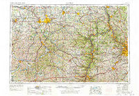
~ Canton OH topo map, 1:250000 scale, 1 X 2 Degree, Historical, 1957, updated 1978
Canton, Ohio, USGS topographic map dated 1957.
Includes geographic coordinates (latitude and longitude). This topographic map is suitable for hiking, camping, and exploring, or framing it as a wall map.
Printed on-demand using high resolution imagery, on heavy weight and acid free paper, or alternatively on a variety of synthetic materials.
Topos available on paper, Waterproof, Poly, or Tyvek. Usually shipping rolled, unless combined with other folded maps in one order.
- Product Number: USGS-5321552
- Free digital map download (high-resolution, GeoPDF): Canton, Ohio (file size: 22 MB)
- Map Size: please refer to the dimensions of the GeoPDF map above
- Weight (paper map): ca. 55 grams
- Map Type: POD USGS Topographic Map
- Map Series: HTMC
- Map Verison: Historical
- Cell ID: 68700
- Scan ID: 224315
- Imprint Year: 1978
- Woodland Tint: Yes
- Visual Version Number: 2
- Edit Year: 1969
- Field Check Year: 1957
- Datum: Unstated
- Map Projection: Transverse Mercator
- Map published by United States Geological Survey
- Map Language: English
- Scanner Resolution: 600 dpi
- Map Cell Name: Canton
- Grid size: 1 X 2 Degree
- Date on map: 1957
- Map Scale: 1:250000
- Geographical region: Ohio, United States
Neighboring Maps:
All neighboring USGS topo maps are available for sale online at a variety of scales.
Spatial coverage:
Topo map Canton, Ohio, covers the geographical area associated the following places:
- Chili - Plumbsock - Jackson Knolls Gardens - Harter Heights - Henderson Heights - Cokeburg Junction - Gordon Trailer Park - Fryburg - Millheim - South Haven Mobile Park - Osborne - Rock Point - Orchard Heights - Williamsport - Corliss - Bell Acres - Ludwigs Mobile Home Park - Allegheny Center - Ruthfred Acres - Arcadian Heights - Boys Village - Sandy Hills Estates - Lincoln Hill - Newell - Washington - Parkridge - Chartiers - Groveton - Wooster Trailer Park - Plain - Hickory - Glencoe - Creston - Hillview Mobile Court - Sunshine Mobile Home Park - Bonnymeade - Beaver Street Trailer Court - Oak Manor - Budaville - Sandy Valley Estates - Lawnfield Estates - Edgebrook - Bertha - Chenoweth Estates - New Cumberland - Hillcrest - Ben Avon - Indianola Estates - Pleasant Valley - Irondale - Rockford - Greentown - North Fredericktown - Lindale Heights - Holt - Esplen - Forest View - New Waterford - Keene - Willow Grove - Hoytdale - Cadiz Junction - Rockwood Park - Vanceville - Noblestown - Hooverson Heights - Blairmont - Saratoga (historical) - Forest View Mobile Home Park - Gayly - Thornburg - Hammondsville - Mapleview Mobile Home Manor - Lynn Center Park - Edmeyer Park - Allendale - Evans City - Brintons Corners - Lawrenceville (historical) - West Library - Canaan - Moultrie - West Lafayette - Moon Run - Gretna - Alliance - Glendwell - Adams Mills - Scenic Ridge - Knights Crossing - Queensboro - Georgetown - Mil-mar Trailer Court - Salida - Glasgow - West Shore Cottage Area - Blainesville - Gould - Taylortown - Fallston
- Map Area ID: AREA4140-82-80
- Northwest corner Lat/Long code: USGSNW41-82
- Northeast corner Lat/Long code: USGSNE41-80
- Southwest corner Lat/Long code: USGSSW40-82
- Southeast corner Lat/Long code: USGSSE40-80
- Northern map edge Latitude: 41
- Southern map edge Latitude: 40
- Western map edge Longitude: -82
- Eastern map edge Longitude: -80


