
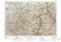
~ Canton OH topo map, 1:250000 scale, 1 X 2 Degree, Historical, 1957, updated 1978
Canton, Ohio, USGS topographic map dated 1957.
Includes geographic coordinates (latitude and longitude). This topographic map is suitable for hiking, camping, and exploring, or framing it as a wall map.
Printed on-demand using high resolution imagery, on heavy weight and acid free paper, or alternatively on a variety of synthetic materials.
Topos available on paper, Waterproof, Poly, or Tyvek. Usually shipping rolled, unless combined with other folded maps in one order.
- Product Number: USGS-5321550
- Free digital map download (high-resolution, GeoPDF): Canton, Ohio (file size: 24 MB)
- Map Size: please refer to the dimensions of the GeoPDF map above
- Weight (paper map): ca. 55 grams
- Map Type: POD USGS Topographic Map
- Map Series: HTMC
- Map Verison: Historical
- Cell ID: 68700
- Scan ID: 224314
- Imprint Year: 1978
- Woodland Tint: Yes
- Edit Year: 1969
- Field Check Year: 1957
- Datum: Unstated
- Map Projection: Transverse Mercator
- Map published by United States Geological Survey
- Map Language: English
- Scanner Resolution: 600 dpi
- Map Cell Name: Canton
- Grid size: 1 X 2 Degree
- Date on map: 1957
- Map Scale: 1:250000
- Geographical region: Ohio, United States
Neighboring Maps:
All neighboring USGS topo maps are available for sale online at a variety of scales.
Spatial coverage:
Topo map Canton, Ohio, covers the geographical area associated the following places:
- South Heights - West Liberty - Rogers - Martins Ferry - Holt - Jethro - Winifred Knoll - Damascus - Atwood Village - Union Ridge - Vulcan - Smithville - Freeport - Belmont Ridge - Echo Dell Mobile Home Park - Willow Glen - The Eastern - Homewood - Ben Avon Heights - Independence - Lake Slagle - Alliance Junction - Morningview - Sundial Mobile Home Park - Myersville - East Carnegie - Plainsburg (historical) - Deer Meadow Mobile Home Park - Westland Park - Castle Shannon - Pleasant Hill - Adena - Shel Mar Mobile Home Park - Alden Park - Federal - Morristown - Mayfair Estates - Circle Green - Dundee - North Island - Ginther (historical) - Bowlings Mobile Home Park - Franklin - Energy - Carman - Parral - Greenford - New Salisbury - Five Forks - Wolfdale - Tower Terrace - Valley - East Finley - Minerva Junction - Yorktown - Upland Heights - Fairview - North Sewickley - Stillwater - Royal Mobile Park - Wooster - Edgefield - North Canton - Colonial Hills - Richville - West Pittsburg - Oakdale - McChesney Meadows - Sewickley Heights - Sunset Valley - North Rochester - Mount Echo - Phillipsburg - Lincoln Heights - Mozart - Boden - North Industry - Mechanicsburg - Minerva - West Lebanon - Clendening (historical) - Kilgore - Bowerston - Mount Eaton - Moravia - Braddock - Old Zollarsville - South Hills - Ginger Hill - East Canton - Belknap - Woods Run - Warwood Terrace - Leatherwood - Hookstown - Mount de Chantal - Uniontown - West Wheeling - Glen Run - Spring Valley Estates
- Map Area ID: AREA4140-82-80
- Northwest corner Lat/Long code: USGSNW41-82
- Northeast corner Lat/Long code: USGSNE41-80
- Southwest corner Lat/Long code: USGSSW40-82
- Southeast corner Lat/Long code: USGSSE40-80
- Northern map edge Latitude: 41
- Southern map edge Latitude: 40
- Western map edge Longitude: -82
- Eastern map edge Longitude: -80


