
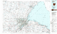
~ Toledo OH topo map, 1:100000 scale, 30 X 60 Minute, Historical, 1986, updated 1986
Toledo, Ohio, USGS topographic map dated 1986.
Includes geographic coordinates (latitude and longitude). This topographic map is suitable for hiking, camping, and exploring, or framing it as a wall map.
Printed on-demand using high resolution imagery, on heavy weight and acid free paper, or alternatively on a variety of synthetic materials.
Topos available on paper, Waterproof, Poly, or Tyvek. Usually shipping rolled, unless combined with other folded maps in one order.
- Product Number: USGS-5321542
- Free digital map download (high-resolution, GeoPDF): Toledo, Ohio (file size: 18 MB)
- Map Size: please refer to the dimensions of the GeoPDF map above
- Weight (paper map): ca. 55 grams
- Map Type: POD USGS Topographic Map
- Map Series: HTMC
- Map Verison: Historical
- Cell ID: 77521
- Scan ID: 228228
- Imprint Year: 1986
- Aerial Photo Year: 1983
- Edit Year: 1986
- Datum: NAD27
- Map Projection: Universal Transverse Mercator
- Planimetric: Yes
- Map published by United States Geological Survey
- Map Language: English
- Scanner Resolution: 600 dpi
- Map Cell Name: Toledo
- Grid size: 30 X 60 Minute
- Date on map: 1986
- Map Scale: 1:100000
- Geographical region: Ohio, United States
Neighboring Maps:
All neighboring USGS topo maps are available for sale online at a variety of scales.
Spatial coverage:
Topo map Toledo, Ohio, covers the geographical area associated the following places:
- Lime City - Sylvania - Dutch Ridge - Hille Farms - Whitehouse - Whiteford Center - Willow Beach - Champion - Patterson Gardens - Shore Acres - East Swanton - Lambertville - Presque Isle (historical) - Siney (historical) - Raisin Center - Belmont Woods - North Shores - Locust Point - Oldport - Samaria - Rivercrest - Boulevard - Candyce Grove - Northwood - Assumption - Crosswoods - Rossford - East Gardens - Stanley - Ottawa Hills - Willowbend - South Swanton - Blissfield - Holloway - Raker Corners - Mayfair Park - Dundee - Limestone - Stony Point - Mound View - Erie Mobile Home Village - Meigs on the River - Rea - Grand View - Saint Anthony - Glenwood - Richfield Center - East Lane Mobile Manor - Linwood Court Mobile Home Park - Silica - Hulls Crossing - Bayer Trailer Court - Meadowbrook Estates Mobile Home Park - Diann - Walbridge - Brighton Gardens - Aztec Subdivision - Mulberry - Luna Pier - Metamora - Hayes Place - Shamrock Mobile Home Village - Steiner - Cedar Creek - Perrysburg Heights - Bates - Oakridge Estates Mobile Home Park - South Delta - Riga - Petersburg - Termway Trailer Court - Ogden Center - Friendly Village II Mobile Home Park - Webb (historical) - Lakemont - Vickers - Forest Park - Northtown Meadows Mobile Home Park - Hallett - Williston - Cresceus Farms - Freemans Gardens - Bieber - The Meadows - Lenawee Junction - Clay Center - Fort Meigs Place - Momeneetown - Grape - Wolf Creek Addition - Cedar Creek Woods - Lytton - Genoa - Belmont Farms - Deerfield - Vulcan - Long Beach - Turnberry Estates - Woodland Beach - Toledo
- Map Area ID: AREA4241.5-84-83
- Northwest corner Lat/Long code: USGSNW42-84
- Northeast corner Lat/Long code: USGSNE42-83
- Southwest corner Lat/Long code: USGSSW41.5-84
- Southeast corner Lat/Long code: USGSSE41.5-83
- Northern map edge Latitude: 42
- Southern map edge Latitude: 41.5
- Western map edge Longitude: -84
- Eastern map edge Longitude: -83


