
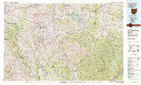
~ Senecaville OH topo map, 1:100000 scale, 30 X 60 Minute, Historical, 1980, updated 1983
Senecaville, Ohio, USGS topographic map dated 1980.
Includes geographic coordinates (latitude and longitude). This topographic map is suitable for hiking, camping, and exploring, or framing it as a wall map.
Printed on-demand using high resolution imagery, on heavy weight and acid free paper, or alternatively on a variety of synthetic materials.
Topos available on paper, Waterproof, Poly, or Tyvek. Usually shipping rolled, unless combined with other folded maps in one order.
- Product Number: USGS-5321536
- Free digital map download (high-resolution, GeoPDF): Senecaville, Ohio (file size: 30 MB)
- Map Size: please refer to the dimensions of the GeoPDF map above
- Weight (paper map): ca. 55 grams
- Map Type: POD USGS Topographic Map
- Map Series: HTMC
- Map Verison: Historical
- Cell ID: 68348
- Scan ID: 226954
- Imprint Year: 1983
- Woodland Tint: Yes
- Aerial Photo Year: 1978
- Edit Year: 1980
- Datum: NAD27
- Map Projection: Universal Transverse Mercator
- Map published by United States Geological Survey
- Map Language: English
- Scanner Resolution: 600 dpi
- Map Cell Name: Senecaville Lake
- Grid size: 30 X 60 Minute
- Date on map: 1980
- Map Scale: 1:100000
- Geographical region: Ohio, United States
Neighboring Maps:
All neighboring USGS topo maps are available for sale online at a variety of scales.
Spatial coverage:
Topo map Senecaville, Ohio, covers the geographical area associated the following places:
- Sharon - Wahanaker - Cannelville - Rosseau - Ward (historical) - Hackney - Crooked Tree - Antioch - Neelysville - Alexis - Ringgold - Sundale - Honesty - Bridgeville - Caldwell - Gaysport - Bloomfield - Elba - Georgetown - Sprague - Dungannon - Brister - Sealover (historical) - Benwood - McDonald - Seawright (historical) - Robins - Mountville - Rowland (historical) - Way - Centerview (historical) - Oakwood - Smith (historical) - Trail Run (historical) - Brush Creek - Chaseville - Blue Rock - Jericho - Lawton (historical) - West Shore Cottage Area - Florence - Germantown - Scott (historical) - New Concord - Rinard Mills - Sonora - Wortley - Brownsville - East Shore Cottage Area - Forest Hills - Fulda - Pennsville - Oakland (historical) - Colonial Heights - Senecaville - Plainview - Griffith - Ashton - Equity - Marysville - Stringtown (historical) - Monroefield - Rado (historical) - Hilltop - Westland - Rokeby Lock - Todds - Altitude - Rich Hill (historical) - Lakeland - Malaga - Lovell - Cedar Run - Cabinville (historical) - Rochester - New Matamoras - Jackson Special - Confederate Crossroads (historical) - Lebanon - High Hill - Zeno - Rose Addition - Dalzell - Seneca Lake Estates - McConnelsville - Gasville - Waterford - Marr - Belle Valley - Griffin - Coal Run - Duvall - Salesville - Poulton - Whigville - Duncan Falls - Dexter City - Blacktop - Stovertown - Fly
- Map Area ID: AREA4039.5-82-81
- Northwest corner Lat/Long code: USGSNW40-82
- Northeast corner Lat/Long code: USGSNE40-81
- Southwest corner Lat/Long code: USGSSW39.5-82
- Southeast corner Lat/Long code: USGSSE39.5-81
- Northern map edge Latitude: 40
- Southern map edge Latitude: 39.5
- Western map edge Longitude: -82
- Eastern map edge Longitude: -81


