
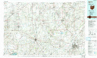
~ Marion OH topo map, 1:100000 scale, 30 X 60 Minute, Historical, 1986, updated 1992
Marion, Ohio, USGS topographic map dated 1986.
Includes geographic coordinates (latitude and longitude). This topographic map is suitable for hiking, camping, and exploring, or framing it as a wall map.
Printed on-demand using high resolution imagery, on heavy weight and acid free paper, or alternatively on a variety of synthetic materials.
Topos available on paper, Waterproof, Poly, or Tyvek. Usually shipping rolled, unless combined with other folded maps in one order.
- Product Number: USGS-5321522
- Free digital map download (high-resolution, GeoPDF): Marion, Ohio (file size: 20 MB)
- Map Size: please refer to the dimensions of the GeoPDF map above
- Weight (paper map): ca. 55 grams
- Map Type: POD USGS Topographic Map
- Map Series: HTMC
- Map Verison: Historical
- Cell ID: 67907
- Scan ID: 225956
- Imprint Year: 1992
- Woodland Tint: Yes
- Photo Inspection Year: 1989
- Aerial Photo Year: 1989
- Edit Year: 1986
- Datum: NAD27
- Map Projection: Universal Transverse Mercator
- Map published by United States Geological Survey
- Map Language: English
- Scanner Resolution: 600 dpi
- Map Cell Name: Marion
- Grid size: 30 X 60 Minute
- Date on map: 1986
- Map Scale: 1:100000
- Geographical region: Ohio, United States
Neighboring Maps:
All neighboring USGS topo maps are available for sale online at a variety of scales.
Spatial coverage:
Topo map Marion, Ohio, covers the geographical area associated the following places:
- Cannonsburg - Highlands of Marion - Arlington - Plankton - Northland Mobile Home Court - Big Springs - Hunters Chase - Air View Acres - Big Island - Walnut Grove - Vanlue - Island View - Tymochtee - Benton - Winnemac (historical) - Holden - Southern Estates - Mexico - Pratts - Maysville - Wharton - Kirby - Walton - Hords (historical) - Beaver Dam Station - River Valley Estates - Hassan (historical) - Bowsherville (historical) - Gurley (historical) - Bridgeport - Otterbein - Jumbo - Yelverton - Country Club Hills - Marshs (historical) - McVitty - Twin Oaks Mobile Home Park - Sixtyeight Trailer Park - Quickstep - Wyandot - Rawson - Quarry Estates - Harpster - Jump - Ruth - Meeker - Crawford - McGuffey - Oakland Mobile Home Park - Chateau Ridge - Eaglewood - Grandview Estates - Pfeiffer - Brownstown - New Stark - Fountain Place Mobile Home Park - Parkview Village North - Owens - Edenville - Seal - Carpenters Corners - Hepburn - Longville (historical) - Mount Blanchard - Van - Waynesfield - Belle Vernon - Colonial Acres - Cordelia - Grant - Kirkpatrick - Tip and Jo's Trailer Park - Brush Ridge - Nevada - Alger - Lykens - DeCliff - Mount Victory - Oceola - Patterson - Holmesville (historical) - Spring Lake Village - Westview Estates - Mentzer - Oak Knoll - Douglass (historical) - Green Meadow Mobile Home Park - Marion - New Hampshire - Carey - Hillcrest Estates - Harrod - Tammis Mobile Village - Ridgeway - Williamstown - Belmont Court - Buckeye Trailer Park - Browns Crossroads - Deunquat - Blocktown (historical)
- Map Area ID: AREA4140.5-84-83
- Northwest corner Lat/Long code: USGSNW41-84
- Northeast corner Lat/Long code: USGSNE41-83
- Southwest corner Lat/Long code: USGSSW40.5-84
- Southeast corner Lat/Long code: USGSSE40.5-83
- Northern map edge Latitude: 41
- Southern map edge Latitude: 40.5
- Western map edge Longitude: -84
- Eastern map edge Longitude: -83


