
~ Marion OH topo map, 1:100000 scale, 30 X 60 Minute, Historical, 1986, updated 1986
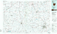
Marion, Ohio, USGS topographic map dated 1986.
Includes geographic coordinates (latitude and longitude). This topographic map is suitable for hiking, camping, and exploring, or framing it as a wall map.
Printed on-demand using high resolution imagery, on heavy weight and acid free paper, or alternatively on a variety of synthetic materials.
Topos available on paper, Waterproof, Poly, or Tyvek. Usually shipping rolled, unless combined with other folded maps in one order.
- Product Number: USGS-5321520
- Free digital map download (high-resolution, GeoPDF): Marion, Ohio (file size: 14 MB)
- Map Size: please refer to the dimensions of the GeoPDF map above
- Weight (paper map): ca. 55 grams
- Map Type: POD USGS Topographic Map
- Map Series: HTMC
- Map Verison: Historical
- Cell ID: 67907
- Scan ID: 225955
- Imprint Year: 1986
- Aerial Photo Year: 1981
- Edit Year: 1986
- Datum: NAD27
- Map Projection: Universal Transverse Mercator
- Planimetric: Yes
- Map published by United States Geological Survey
- Map Language: English
- Scanner Resolution: 600 dpi
- Map Cell Name: Marion
- Grid size: 30 X 60 Minute
- Date on map: 1986
- Map Scale: 1:100000
- Geographical region: Ohio, United States
Neighboring Maps:
All neighboring USGS topo maps are available for sale online at a variety of scales.
Spatial coverage:
Topo map Marion, Ohio, covers the geographical area associated the following places:
- Crawford - Parkway Mobile Home Village - Upper Sandusky - Twin Oaks Mobile Home Park - Ada - Bluffton - Logan (historical) - Big Springs - Maysville - DeCliff - Lemert - Spore - Hunters Chase - Patterson - Brush Ridge - Quarry Estates - Longville (historical) - Mount Blanchard - Grant - Crystal Lakes - Fountain Place Mobile Home Park - Deunquat - South Park - Sixtyeight Trailer Park - Island View - Martinstown (historical) - Buckeye Trailer Park - Belmont Court - New Hampshire - Air View Acres - Harrod - Wharton - Cannonsburg - Rawson - Southern Estates - Huntersville - Mount Cory - Grandview Estates - Little Sandusky - Gurley (historical) - Marshs (historical) - Mexico - Grassy Point - Pfeiffer - Glenville (historical) - Nevada - Quickstep - Chateau Ridge - New Stark - Northland Mobile Home Court - Walton - Big Island - Spring Lake Village - Mount Victory - Ruth - Waynesfield - Plankton - Van - Westminster - Green Meadow Mobile Home Park - Forest - Kirkpatrick - Pratts - Bridgeport - Beaver Dam Station - Mentzer - Hassan (historical) - Carpenters Corners - Carey Mobile Home Estates - Blanchard - Green Camp - Alger - Lafayette - Dola - Carey - Vanlue - Wyandot - Jenera - Rush Mobile Home Park - Belle Center - Eaglewood - Winnemac (historical) - River Valley Estates - Smithville - Yelverton - Douglass (historical) - Pleasant Acres Mobile Home Park - Marion - Avondale - Meeker - Chippewa Park - Lykens - Hepburn - La Rue - Holiday Shores Mobile Home Park - Seal - New Bloomington - Harpster - Tobias - West Newton
- Map Area ID: AREA4140.5-84-83
- Northwest corner Lat/Long code: USGSNW41-84
- Northeast corner Lat/Long code: USGSNE41-83
- Southwest corner Lat/Long code: USGSSW40.5-84
- Southeast corner Lat/Long code: USGSSE40.5-83
- Northern map edge Latitude: 41
- Southern map edge Latitude: 40.5
- Western map edge Longitude: -84
- Eastern map edge Longitude: -83


