
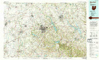
~ Mansfield OH topo map, 1:100000 scale, 30 X 60 Minute, Historical, 1994, updated 1994
Mansfield, Ohio, USGS topographic map dated 1994.
Includes geographic coordinates (latitude and longitude). This topographic map is suitable for hiking, camping, and exploring, or framing it as a wall map.
Printed on-demand using high resolution imagery, on heavy weight and acid free paper, or alternatively on a variety of synthetic materials.
Topos available on paper, Waterproof, Poly, or Tyvek. Usually shipping rolled, unless combined with other folded maps in one order.
- Product Number: USGS-5321516
- Free digital map download (high-resolution, GeoPDF): Mansfield, Ohio (file size: 25 MB)
- Map Size: please refer to the dimensions of the GeoPDF map above
- Weight (paper map): ca. 55 grams
- Map Type: POD USGS Topographic Map
- Map Series: HTMC
- Map Verison: Historical
- Cell ID: 72645
- Scan ID: 225712
- Imprint Year: 1994
- Woodland Tint: Yes
- Aerial Photo Year: 1991
- Edit Year: 1994
- Datum: NAD27
- Map Projection: Universal Transverse Mercator
- Map published by United States Geological Survey
- Map Language: English
- Scanner Resolution: 600 dpi
- Map Cell Name: Mansfield
- Grid size: 30 X 60 Minute
- Date on map: 1994
- Map Scale: 1:100000
- Geographical region: Ohio, United States
Neighboring Maps:
All neighboring USGS topo maps are available for sale online at a variety of scales.
Spatial coverage:
Topo map Mansfield, Ohio, covers the geographical area associated the following places:
- Hines (historical) - Sulphur Springs - Craigton - Olentangy Estates - Ashfield Estates Mobile Home Park - Bangorville - Eight Square (historical) - Mifflin Cottage Area - Saint James - Bucyrus - Mechanicsburg - Cesarea - Fleming Falls - Lexington - Twin Mobile Home Park - North Auburn - Shauck - Sites Lake Cottage Area - Carrothers - Meadowbrook Mobile Home Park - Edison - Mobile Manor Park - Ganges - Midpoint Woods - Jelloway - New Wheeling (historical) - Pulaskiville - Five Points - Shady Lane Mobile Home Park - River Edge Mobile Park - Northwood Estates - Briarwood Estates Mobile Home Park - Spring Valley Court - Paradise Hill - Steam Corners - South Boulevards - Charles Mill - Tiro - Bellville - Jefferson - Shreve - Greer - Blachleyville - Myers (historical) - Williamsport - Cardington - Claridon - Saint Johns (historical) - Ankenytown - Batemantown - Pavonia - Epworth - Roseland - Trailerville Mobile Home Park - England - Shenandoah - Planktown - Mount Gilead - Leesville - Iberia - Biddle (historical) - West Liberty - Newville - Hillside Mobile Home Park - Spring Mill - Pinecrest Mobile Home Park - Galion - West Salem - Dale Avenue Mobile Home Park - Paint Valley - Treaton - Crimson - Weir Mobile Home Park - Stewart (historical) - Albion - Savannah - Beech (historical) - Colonial Hills - Richland (historical) - Auburn Center - Chatfield - Coulter - Westview Mobile Home Park - Lincoln Heights - Sunnyview - Bethlehem - Millbrook - North Liberty - Gardner - Armstrong - Hayesville - Big Prairie - Brandywine - Toledo Junction - Vernon Junction - Jugs Corners - Hidden Valley Mobile Home Park - Linden Park - Lakeland Beach - Fairview Mobile Home Park
- Map Area ID: AREA4140.5-83-82
- Northwest corner Lat/Long code: USGSNW41-83
- Northeast corner Lat/Long code: USGSNE41-82
- Southwest corner Lat/Long code: USGSSW40.5-83
- Southeast corner Lat/Long code: USGSSE40.5-82
- Northern map edge Latitude: 41
- Southern map edge Latitude: 40.5
- Western map edge Longitude: -83
- Eastern map edge Longitude: -82


