
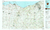
~ Lorain OH topo map, 1:100000 scale, 30 X 60 Minute, Historical, 1986, updated 1990
Lorain, Ohio, USGS topographic map dated 1986.
Includes geographic coordinates (latitude and longitude). This topographic map is suitable for hiking, camping, and exploring, or framing it as a wall map.
Printed on-demand using high resolution imagery, on heavy weight and acid free paper, or alternatively on a variety of synthetic materials.
Topos available on paper, Waterproof, Poly, or Tyvek. Usually shipping rolled, unless combined with other folded maps in one order.
- Product Number: USGS-5321514
- Free digital map download (high-resolution, GeoPDF): Lorain, Ohio (file size: 20 MB)
- Map Size: please refer to the dimensions of the GeoPDF map above
- Weight (paper map): ca. 55 grams
- Map Type: POD USGS Topographic Map
- Map Series: HTMC
- Map Verison: Historical
- Cell ID: 67870
- Scan ID: 225915
- Imprint Year: 1990
- Woodland Tint: Yes
- Aerial Photo Year: 1983
- Edit Year: 1986
- Datum: NAD27
- Map Projection: Universal Transverse Mercator
- Map published by United States Geological Survey
- Map Language: English
- Scanner Resolution: 600 dpi
- Map Cell Name: Lorain
- Grid size: 30 X 60 Minute
- Date on map: 1986
- Map Scale: 1:100000
- Geographical region: Ohio, United States
Neighboring Maps:
All neighboring USGS topo maps are available for sale online at a variety of scales.
Spatial coverage:
Topo map Lorain, Ohio, covers the geographical area associated the following places:
- Hanville Corners - North Milan - Coonville - Holiday Estates - Risley (historical) - Crystal Rock - Spears Corners - Rochester - Vickery - Harbourtown Mobile Home Community - Belden - Westwood Mobile Estates - Sheffield - Avon - Bluebird Beach - Huron Valley Mobile Home Park - Newtons (historical) - Chatham - Sand Hill - New London - Trinity (historical) - Erie West Mobile Home Park - Homerville - Laporte - Heidelberg Beach - Pikewood Manor - Avon Center - Oberlin - Steuben - Vincent - Ashmont (historical) - Spencer - Whitmore - Hunts Corners - Bayshore Estates Mobile Home Park - Brownhelm Station - Milan - Harry's Mobile Home Park - Pine Villas - North Fairfield - Ridgewood Mobile Home Park - Fireside - Bay View - West Clarksfield - Parkertown - Portland Court - Shawville (historical) - Bayshore - Evergreen Estates - Reedtown - Penfield Junction - Sandusky - Weavers Corners - Axtel - Henrietta - Branchwood Estates - Pittsfield - Ceylon - Camden - Anchor Mobile Home Park - Lagrange - North Ridgeville - Grafton - Sheffield Lake - Fitchville - Shinrock - Clyde - Bogart - Collins - Gypsum - Huntington - Rye beach - Riverview Mobile Home Park - Kingsleys Corners - Penfield - Boughtonville - Omar - Columbus Park - Darby Place Mobile Home Park - Wellington Mobile Home Park - East Norwalk - Colonial Oaks - Saint Stephens - Semples - Peru - River Corners - Anderson - Centerville (historical) - Sunset Mobile Home Park - Ruggles Beach - Attica Junction - Hartland - Kipton - Delphi - Eaton - Ogontz - Colonial Villa - Attica - Brentwood Lake - Edgewater Estates
- Map Area ID: AREA41.541-83-82
- Northwest corner Lat/Long code: USGSNW41.5-83
- Northeast corner Lat/Long code: USGSNE41.5-82
- Southwest corner Lat/Long code: USGSSW41-83
- Southeast corner Lat/Long code: USGSSE41-82
- Northern map edge Latitude: 41.5
- Southern map edge Latitude: 41
- Western map edge Longitude: -83
- Eastern map edge Longitude: -82


