
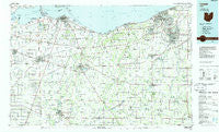
~ Lorain OH topo map, 1:100000 scale, 30 X 60 Minute, Historical, 1986, updated 1986
Lorain, Ohio, USGS topographic map dated 1986.
Includes geographic coordinates (latitude and longitude). This topographic map is suitable for hiking, camping, and exploring, or framing it as a wall map.
Printed on-demand using high resolution imagery, on heavy weight and acid free paper, or alternatively on a variety of synthetic materials.
Topos available on paper, Waterproof, Poly, or Tyvek. Usually shipping rolled, unless combined with other folded maps in one order.
- Product Number: USGS-5321512
- Free digital map download (high-resolution, GeoPDF): Lorain, Ohio (file size: 18 MB)
- Map Size: please refer to the dimensions of the GeoPDF map above
- Weight (paper map): ca. 55 grams
- Map Type: POD USGS Topographic Map
- Map Series: HTMC
- Map Verison: Historical
- Cell ID: 67870
- Scan ID: 225914
- Imprint Year: 1986
- Woodland Tint: Yes
- Aerial Photo Year: 1983
- Edit Year: 1986
- Datum: NAD27
- Map Projection: Universal Transverse Mercator
- Planimetric: Yes
- Map published by United States Geological Survey
- Map Language: English
- Scanner Resolution: 600 dpi
- Map Cell Name: Lorain
- Grid size: 30 X 60 Minute
- Date on map: 1986
- Map Scale: 1:100000
- Geographical region: Ohio, United States
Neighboring Maps:
All neighboring USGS topo maps are available for sale online at a variety of scales.
Spatial coverage:
Topo map Lorain, Ohio, covers the geographical area associated the following places:
- Lake Breeze - Castalia - Pheasant Run Village - Clyde - Geisingers Corners (historical) - Ceylon - Prout (historical) - Willard Mobile Home Park - Penfield Junction - Monroeville - Weyers - Branchwood Estates - Westview Estates - Huntington - Greenfield Village Mobile Home Park - Abbe Road Trailer Park - Willard - Sullivan - River Corners - Risley (historical) - Eaton - Bayshore - Ruggles - Relief (historical) - Olena - Pine Villas - Darby Place Mobile Home Park - Berlin Heights - Berlinville - Elyria - Bayshore Estates Mobile Home Park - Peru - Sandusky - Hartland Station - Greenwich - North Milan - Saint Stephens - Vermilion - Siam - Havana - Brighton - West Clarksfield - Sheffield Lake - Amherst - Fireside - Shiperd Circle - Centerville (historical) - Lagrange - Attica Junction - Bay View - Beulah Beach - Strongs Ridge - Bogart - Whites Landing - Lodi - Lincolnshire - Oberlin Beach - Reedtown - Portland Court - South Amherst - Evergreen Estates - Bellevue - Garden Isle - Hanville Corners - Key Estates - Lakeshore Mobile Homes - Nova - Frank - Galetown - Penfield - Ogontz - Teemes (historical) - Rye beach - Holiday Estates - Mount Pleasant - Kimball - Westwood Mobile Estates - Vickery - Westwoods Mobile Home Park - Brookside Mobile Home Park - East Townsend - Crystal Rock - Herefork - Wilmer - Eastowne Mobile Home Estates - Florence - Rugby (historical) - Esselburn - Baywater Estates - North Palm Beach - Henrietta - Sheefel Mobile Home Park - Boughtonville - Chaska Beach - Grand Forest Beach - Grafton - New London - Colby - West Lodi - Hunts Corners
- Map Area ID: AREA41.541-83-82
- Northwest corner Lat/Long code: USGSNW41.5-83
- Northeast corner Lat/Long code: USGSNE41.5-82
- Southwest corner Lat/Long code: USGSSW41-83
- Southeast corner Lat/Long code: USGSSE41-82
- Northern map edge Latitude: 41.5
- Southern map edge Latitude: 41
- Western map edge Longitude: -83
- Eastern map edge Longitude: -82


