
~ Lima OH topo map, 1:100000 scale, 30 X 60 Minute, Historical, 1986, updated 1992
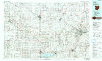
Lima, Ohio, USGS topographic map dated 1986.
Includes geographic coordinates (latitude and longitude). This topographic map is suitable for hiking, camping, and exploring, or framing it as a wall map.
Printed on-demand using high resolution imagery, on heavy weight and acid free paper, or alternatively on a variety of synthetic materials.
Topos available on paper, Waterproof, Poly, or Tyvek. Usually shipping rolled, unless combined with other folded maps in one order.
- Product Number: USGS-5321508
- Free digital map download (high-resolution, GeoPDF): Lima, Ohio (file size: 19 MB)
- Map Size: please refer to the dimensions of the GeoPDF map above
- Weight (paper map): ca. 55 grams
- Map Type: POD USGS Topographic Map
- Map Series: HTMC
- Map Verison: Historical
- Cell ID: 67846
- Scan ID: 225902
- Imprint Year: 1992
- Woodland Tint: Yes
- Photo Inspection Year: 1989
- Aerial Photo Year: 1981
- Edit Year: 1986
- Datum: NAD27
- Map Projection: Universal Transverse Mercator
- Map published by United States Geological Survey
- Map Language: English
- Scanner Resolution: 600 dpi
- Map Cell Name: Lima
- Grid size: 30 X 60 Minute
- Date on map: 1986
- Map Scale: 1:100000
- Geographical region: Ohio, United States
Neighboring Maps:
All neighboring USGS topo maps are available for sale online at a variety of scales.
Spatial coverage:
Topo map Lima, Ohio, covers the geographical area associated the following places:
- Converse - Holland Court - Abanaka - Glenmore - Duckfoot Landing - Club Island - Ceylon - Montana (historical) - Cavett - Pusheta Town (historical) - East Liberty - Gutman - Cridersville Trailer Park - Willshire - Saint Marys - Jay City - Jones City - Clevengers (historical) - Meyers Mobile Home Park - Abbeywood Estates - Wapakoneta - Southworth - Ottoville - Allentown - Hunters Chase - South Warsaw - Hoagland - Durbin - Rockford - Gomer - Rimer - Seitz - Rousculp - Bass Landing - Bell Avenue Trailer Court - Breezewood - Ridge Road Trailer Park - Kossuth - Hartford (historical) - Middle Point - Ulm's Mobile Home Court II - Crestwood Mobile Home Park - Rushmore - Sandy Beach - Scudder - Doss Landing - Highland Park - Villa Nova - Elida - Bulkhead - Offenbacher Mobile Home Park - Middlebury - Richey - Wabash - Columbia Estates Mobile Home Park - Bursville - Celina - Geneva - Salem - Coppess Corner - Northwood - Buckland - Rineharts (historical) - Scott - Gordons Trailer Court - Dixon - Fort Jennings - Rockport - Delphos - Colony Mobile Home Park - Columbus Grove - Green Acres - Landeck - Kemp - Bryant - Yoder - Shively - Mendon - Schumm - Mariners Point - Ohio City - Williams - Shady Grove (historical) - Bali Hai Mobile Home Park - Saint Johns - Plaza Mobile Home Park - Village Courts II - Decatur - Four Seasons Trailer Park - Gettman Trailer Park - Hoaglin - Briarwood Court - Livingston Mobile Home Park - The Maples - Vaughnsville - Elmview - Lees Landing - Do Well Mobile Village - Montezuma Acres - Fort Shawnee
- Map Area ID: AREA4140.5-85-84
- Northwest corner Lat/Long code: USGSNW41-85
- Northeast corner Lat/Long code: USGSNE41-84
- Southwest corner Lat/Long code: USGSSW40.5-85
- Southeast corner Lat/Long code: USGSSE40.5-84
- Northern map edge Latitude: 41
- Southern map edge Latitude: 40.5
- Western map edge Longitude: -85
- Eastern map edge Longitude: -84


