
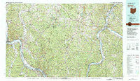
~ Ironton OH topo map, 1:100000 scale, 30 X 60 Minute, Historical, 1981, updated 1982
Ironton, Ohio, USGS topographic map dated 1981.
Includes geographic coordinates (latitude and longitude). This topographic map is suitable for hiking, camping, and exploring, or framing it as a wall map.
Printed on-demand using high resolution imagery, on heavy weight and acid free paper, or alternatively on a variety of synthetic materials.
Topos available on paper, Waterproof, Poly, or Tyvek. Usually shipping rolled, unless combined with other folded maps in one order.
- Product Number: USGS-5321502
- Free digital map download (high-resolution, GeoPDF): Ironton, Ohio (file size: 33 MB)
- Map Size: please refer to the dimensions of the GeoPDF map above
- Weight (paper map): ca. 55 grams
- Map Type: POD USGS Topographic Map
- Map Series: HTMC
- Map Verison: Historical
- Cell ID: 67714
- Scan ID: 225392
- Imprint Year: 1982
- Woodland Tint: Yes
- Aerial Photo Year: 1975
- Edit Year: 1981
- Datum: NAD27
- Map Projection: Universal Transverse Mercator
- Map published by United States Geological Survey
- Map Language: English
- Scanner Resolution: 600 dpi
- Map Cell Name: Ironton
- Grid size: 30 X 60 Minute
- Date on map: 1981
- Map Scale: 1:100000
- Geographical region: Ohio, United States
Neighboring Maps:
All neighboring USGS topo maps are available for sale online at a variety of scales.
Spatial coverage:
Topo map Ironton, Ohio, covers the geographical area associated the following places:
- Hecla - Deering - Cora - Rappsburg - Silver Run - Rubyville - Point Pleasant - Orchard Hill - Bald Knob - Gallia - Greasy Ridge - Vega - Lucasville - York - Horeb - Pedro - Slocum - Maloneton - Clover - Lisman - Sand Hill - Swann - South Shore - Raceland Junction - Petersburg - Hanersville - Grandview Estates - Pinkerman - Greer - Adamsville - Eifort - Maggie - Ida (historical) - Flaxton (historical) - Sciotodale - East Portsmouth (historical) - Haverhill - Olive Furnace - Northup - Portsmouth - Mohrtown - Moulton (historical) - Harrisburg - Rock Camp - Mercerville - Flatrock - Wheelers Mill - Edgington - Thivener - Porterbrook - Stockton (historical) - Buckhorn - Patriot - Modern Mobile Home Park - Hollis (historical) - Orpheus - Siloam - Keystone - Kanauga - Hawk Subdivision - Blackfork Junction - Rigrish Addition - Angel - Boggs (historical) - Millersport - Hallwood - Green Bottom - Kitchen - Center Station - Ironton - Maxatawney Subdivision - Wigner (historical) - Five Forks - The Meadows - Madland (historical) - Fullerton - Grays Branch - Preston Subdivision - Oldtown (historical) - Sand Fork - Three Oaks - Morton Flats - Evans Heights - Rosemount - Beechy - Gwinn - Oak Hill - Manker (historical) - Siloam (historical) - Arlee - Hogsett - Allentown - Spring Valle Estates - Flatwoods - Couch - Mercers Bottom - Bondclay - Cockrell Run - Lawrence Furnace - Carlton
- Map Area ID: AREA3938.5-83-82
- Northwest corner Lat/Long code: USGSNW39-83
- Northeast corner Lat/Long code: USGSNE39-82
- Southwest corner Lat/Long code: USGSSW38.5-83
- Southeast corner Lat/Long code: USGSSE38.5-82
- Northern map edge Latitude: 39
- Southern map edge Latitude: 38.5
- Western map edge Longitude: -83
- Eastern map edge Longitude: -82


