
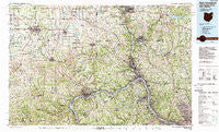
~ East Liverpool OH topo map, 1:100000 scale, 30 X 60 Minute, Historical, 1986, updated 1989
East Liverpool, Ohio, USGS topographic map dated 1986.
Includes geographic coordinates (latitude and longitude). This topographic map is suitable for hiking, camping, and exploring, or framing it as a wall map.
Printed on-demand using high resolution imagery, on heavy weight and acid free paper, or alternatively on a variety of synthetic materials.
Topos available on paper, Waterproof, Poly, or Tyvek. Usually shipping rolled, unless combined with other folded maps in one order.
- Product Number: USGS-5321492
- Free digital map download (high-resolution, GeoPDF): East Liverpool, Ohio (file size: 30 MB)
- Map Size: please refer to the dimensions of the GeoPDF map above
- Weight (paper map): ca. 55 grams
- Map Type: POD USGS Topographic Map
- Map Series: HTMC
- Map Verison: Historical
- Cell ID: 67452
- Scan ID: 226048
- Imprint Year: 1989
- Woodland Tint: Yes
- Aerial Photo Year: 1983
- Edit Year: 1986
- Datum: NAD27
- Map Projection: Universal Transverse Mercator
- Map published by United States Geological Survey
- Map Language: English
- Scanner Resolution: 600 dpi
- Map Cell Name: East Liverpool
- Grid size: 30 X 60 Minute
- Date on map: 1986
- Map Scale: 1:100000
- Geographical region: Ohio, United States
Neighboring Maps:
All neighboring USGS topo maps are available for sale online at a variety of scales.
Spatial coverage:
Topo map East Liverpool, Ohio, covers the geographical area associated the following places:
- Ambridge Heights - Hookstown - Pulaski - Lynn Mobile Manor - Beaver Falls - McConnells Mill - Jackson Knolls Gardens - New Garden - Patterson Heights - Possum Hollow - Fox Ridge - Walkers - New Middletown - Bradford Woods - Longs Crossing - Fairhaven - Eidenau - Sunshine Mobile Home Park - Lockbridge (historical) - Stratton - Sewickley - New Beaver - Glenwillard - Newell - Darlington - New Waterford - Conway - Keown - Blackhawk - Turkeyfoot (historical) - Locust Grove - Marion Hill - Boyer - Glen Eden - Ohioview - Dawson - Glendale - Fairview - Christytown - Myoma - Brintons Corners - Industry - Echo Dell Mobile Home Park - Farr Hill Mobile Home Park - Middle Lancaster - Lake Arthur Estates - Castlewood - Washingtonville - Porters Corners - East Fairfield - Evans City - Connoquenessing - Fombell - Fox Run - Crestmont Village - Pyles Mills - Jimtown - Sugar Grove - Lillyville - South New Castle - Ginger Hill - Franklin Square - Wexford - Hazen - Signal - Valley - Five Forks - West Mayfield - Glasgow - Midland - College Hill - Ben Avon - Pleasant Hill - Perrysville - East Lewistown - Moon Crest - Greenford - Leetsdale - Campus - Zelienople - New Middleton - Salem Mobile Home Park - Unity - Mechanicstown - Hoytdale - Scottsville - New Brighton - New Buffalo - Mahoningtown - Aliquippa - Millville - Berkeley Hills - Marquis - Bridgewater - Subrosa (historical) - Smiths Ferry - Holt - Montour Junction - Guilford - Sunnyside
- Map Area ID: AREA4140.5-81-80
- Northwest corner Lat/Long code: USGSNW41-81
- Northeast corner Lat/Long code: USGSNE41-80
- Southwest corner Lat/Long code: USGSSW40.5-81
- Southeast corner Lat/Long code: USGSSE40.5-80
- Northern map edge Latitude: 41
- Southern map edge Latitude: 40.5
- Western map edge Longitude: -81
- Eastern map edge Longitude: -80


