
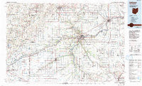
~ Defiance OH topo map, 1:100000 scale, 30 X 60 Minute, Historical, 1986, updated 1992
Defiance, Ohio, USGS topographic map dated 1986.
Includes geographic coordinates (latitude and longitude). This topographic map is suitable for hiking, camping, and exploring, or framing it as a wall map.
Printed on-demand using high resolution imagery, on heavy weight and acid free paper, or alternatively on a variety of synthetic materials.
Topos available on paper, Waterproof, Poly, or Tyvek. Usually shipping rolled, unless combined with other folded maps in one order.
- Product Number: USGS-5321488
- Free digital map download (high-resolution, GeoPDF): Defiance, Ohio (file size: 18 MB)
- Map Size: please refer to the dimensions of the GeoPDF map above
- Weight (paper map): ca. 55 grams
- Map Type: POD USGS Topographic Map
- Map Series: HTMC
- Map Verison: Historical
- Cell ID: 72152
- Scan ID: 226015
- Imprint Year: 1992
- Woodland Tint: Yes
- Photo Inspection Year: 1989
- Aerial Photo Year: 1983
- Edit Year: 1986
- Datum: NAD27
- Map Projection: Universal Transverse Mercator
- Map published by United States Geological Survey
- Map Language: English
- Scanner Resolution: 600 dpi
- Map Cell Name: Defiance
- Grid size: 30 X 60 Minute
- Date on map: 1986
- Map Scale: 1:100000
- Geographical region: Ohio, United States
Neighboring Maps:
All neighboring USGS topo maps are available for sale online at a variety of scales.
Spatial coverage:
Topo map Defiance, Ohio, covers the geographical area associated the following places:
- Milan Center - Payne - Riverview Park Subdivision - Wilna - Dorninton - Croswell - Mooney Meadows Subdivision - Rachel Heights - Gallup - Sophia (historical) - Prentiss - Cuba - Shunk - Green Acres Estates - Ottawa - Zulu - El Grande Estates - Freedom (historical) - East Mandale - Charloe - Hartsburg - Nindeville (historical) - Ball Subdivision - Newville Center - Ratsville - Farmer - Krohns Acres - Arthur - Williams Center - Holgate - Beverly Trailer Park - Lawtonville (historical) - Etties-Burg (historical) - Edgerton - Upper Tauwa (historical) - Moats - Okolona - Cloverleaf (historical) - Grover Hill - Lakeland Woods Estates - Sherwood - Melbern - Napoleon - Canalport - McDonald Subdivision - Orangeville - Butler - Gerald - Timberville (historical) - Logan - Haviland - Huntstown (historical) - North Creek - Roselms - Pleasant Bend - Miller City - Lichtys Parcels - Logtown - Maumee Valley Mobile Home Park - New Harrison (historical) - Follmer (historical) - Continental - Evansport - Antwerp - Sinns Subdivision - Cecil - Hohenberger Trailer Court - Baldwin - Riggs Subdivision - The Bend - Countryside Estates - Green Acres Mobile Home Park - Wilseyville (historical) - Riverbend Mobile Home Park - Mark Center - Spring Meadows - Broughton - Mina - Williamstown - Four Presidents Corners - Millers Rolling Hills Estates - Bryan - Elery - Goodwin (historical) - Newville - Melrose - Five Points - Hamler - New Bavaria - Worstville - Claybaugh Trailer Park - Smiley (historical) - Plumbs Cross Roads (historical) - Colters Mobile Home Park - Independence - Halls Corners - Mobile Manor - Valleybrook Estates - Bluecast - Oakwood
- Map Area ID: AREA41.541-85-84
- Northwest corner Lat/Long code: USGSNW41.5-85
- Northeast corner Lat/Long code: USGSNE41.5-84
- Southwest corner Lat/Long code: USGSSW41-85
- Southeast corner Lat/Long code: USGSSE41-84
- Northern map edge Latitude: 41.5
- Southern map edge Latitude: 41
- Western map edge Longitude: -85
- Eastern map edge Longitude: -84


