
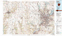
~ Dayton OH topo map, 1:100000 scale, 30 X 60 Minute, Historical, 1986, updated 1990
Dayton, Ohio, USGS topographic map dated 1986.
Includes geographic coordinates (latitude and longitude). This topographic map is suitable for hiking, camping, and exploring, or framing it as a wall map.
Printed on-demand using high resolution imagery, on heavy weight and acid free paper, or alternatively on a variety of synthetic materials.
Topos available on paper, Waterproof, Poly, or Tyvek. Usually shipping rolled, unless combined with other folded maps in one order.
- Product Number: USGS-5321486
- Free digital map download (high-resolution, GeoPDF): Dayton, Ohio (file size: 24 MB)
- Map Size: please refer to the dimensions of the GeoPDF map above
- Weight (paper map): ca. 55 grams
- Map Type: POD USGS Topographic Map
- Map Series: HTMC
- Map Verison: Historical
- Cell ID: 67387
- Scan ID: 226004
- Imprint Year: 1990
- Woodland Tint: Yes
- Aerial Photo Year: 1984
- Edit Year: 1986
- Datum: NAD27
- Map Projection: Universal Transverse Mercator
- Map published by United States Geological Survey
- Map Language: English
- Scanner Resolution: 600 dpi
- Map Cell Name: Dayton
- Grid size: 30 X 60 Minute
- Date on map: 1986
- Map Scale: 1:100000
- Geographical region: Ohio, United States
Neighboring Maps:
All neighboring USGS topo maps are available for sale online at a variety of scales.
Spatial coverage:
Topo map Dayton, Ohio, covers the geographical area associated the following places:
- Fosterville - Sunny Acres Mobile Home Park - West Elkton - Sunshine Mobile Home Park - Dayton - Hewitt - Farmersville - Kitchel - Salem - Kreitzer Corner - Corwin - Circle Z Mobile Home Park - Catalpa Grove Mobile Home Park - Tadmor (historical) - Whitfield - Short Hills - Ithaca - Browns Chapel - Hearthstone - Lindenhall - Taylorsburg - Shady Acres Mobile Home Court - New Madison - West Manchester - Post Town - Bath - West Florence - Springboro - Main Meadows Mobile Home Park - Camden - Gratis - Wright Patterson Mobile Home Park - Drive In Mobile Home Park - Vandalia - Hooks Corner - Sampleville - Nashville - Five Points - Fairview - Shanersville - Carlisle - Hamburg - Willowick - Cottage Grove - Verona - Fairhaven - Poast Town Heights - Union - Wayne - Shiloh - Quail Trail - Ludlow Falls - Voyager Village West - Carmonte - Park Terrace Mobile Home Park - West Alexandria - Morgan Place - Manor (historical) - New Carlisle - Charlottesville - South Richmond - Castine - Lewisburg - Womacks Mobile Home Park - Locust Grove - Garland - Savona - Abington - Rose Lawn - Lamme-Moraine Mobile Home Park - Roxanna - Billingsville - Crosswick - Yankee Town - Clayton - Ideal Mobile Home Park - Astoria - Brinley - Daytonview - Kingsville (historical) - Braffetsville - Webster - Wiley (historical) - Avondale Trailer Court - Ebenezer - West Milton - Pineview Estates - Avondale - Clement - Greenbush - Euphemia - Pinchtown (historical) - Poast Town - Belmont - Dunlapsville - Fountain City - Hide A Way Mobile Home Park - Cains Mobile Home Park - Murlin Heights - Fairborn
- Map Area ID: AREA4039.5-85-84
- Northwest corner Lat/Long code: USGSNW40-85
- Northeast corner Lat/Long code: USGSNE40-84
- Southwest corner Lat/Long code: USGSSW39.5-85
- Southeast corner Lat/Long code: USGSSE39.5-84
- Northern map edge Latitude: 40
- Southern map edge Latitude: 39.5
- Western map edge Longitude: -85
- Eastern map edge Longitude: -84


