
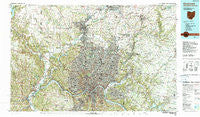
~ Cincinnati OH topo map, 1:100000 scale, 30 X 60 Minute, Historical, 1986, updated 1990
Cincinnati, Ohio, USGS topographic map dated 1986.
Includes geographic coordinates (latitude and longitude). This topographic map is suitable for hiking, camping, and exploring, or framing it as a wall map.
Printed on-demand using high resolution imagery, on heavy weight and acid free paper, or alternatively on a variety of synthetic materials.
Topos available on paper, Waterproof, Poly, or Tyvek. Usually shipping rolled, unless combined with other folded maps in one order.
- Product Number: USGS-5321470
- Free digital map download (high-resolution, GeoPDF): Cincinnati, Ohio (file size: 31 MB)
- Map Size: please refer to the dimensions of the GeoPDF map above
- Weight (paper map): ca. 55 grams
- Map Type: POD USGS Topographic Map
- Map Series: HTMC
- Map Verison: Historical
- Cell ID: 67296
- Scan ID: 226402
- Imprint Year: 1990
- Woodland Tint: Yes
- Visual Version Number: 1
- Aerial Photo Year: 1984
- Edit Year: 1986
- Datum: NAD27
- Map Projection: Universal Transverse Mercator
- Map published by United States Geological Survey
- Map Language: English
- Scanner Resolution: 600 dpi
- Map Cell Name: Cincinnati
- Grid size: 30 X 60 Minute
- Date on map: 1986
- Map Scale: 1:100000
- Geographical region: Ohio, United States
Neighboring Maps:
All neighboring USGS topo maps are available for sale online at a variety of scales.
Spatial coverage:
Topo map Cincinnati, Ohio, covers the geographical area associated the following places:
- Orchard Acres - Springvale - Olde West Chester - Winton Place - Frenchmens Corner (historical) - Country Club Highlands - Excello - DeCoursey - Kenwood Knolls - Rossford - Amelia - The Estates At Wiedemann Mansion - Ross - Park Place - Mount Holly - Oakley - Brookside Estates - Pringle Corners - Woodsdale - Normandy Heights - Peoria - Johns Hill - Skyline Acres - North Bend - Hill Top Acres - North Excello - Fernald - Lawrenceburg - San Je Village - Fulton - Francisville - Norwood - Clare - Westchester - Port Union - Columbia Heights - Cleves - Tusculum - Lynnview - Marathon - Ninemile - Dodsworth Lane (historical) - Stratford Manor - Linn-Crest Acres - Riverview Heights - Dornbusch - Barnesburg - Lincoln Court - Gieringer - Sharonville - Mount Forest Trails - Amity - Summit Hills Heights - Braziers - Monfort Heights - Bethany - Maurice - Greenhills - Ross - Hyde Park - Withamsville - Red Bank - Griesmer Addition - Werk Place - Homewood - Jones (historical) - Norwood Heights - Lower Price Hill - Fairfield - Anderson Ferry - Beechwood (historical) - Hanover (historical) - Hooven - Auburn - McGonigle - Ixworth (historical) - Mount Saint Joseph - Lincoln Heights - Sedamsville - Bromley - Schenck - Bullittsburg (historical) - Fairham Heights - Bevis - Wetherington - Locust Corner - College Hill - Afton - Golf Manor - Liberty Trails - Prospect Hill - Lawrenceburg Junction - Trenton - Edgewood - Dutchland Woods - Grainthorpe (historical) - Mulberry - Stokes (historical) - Dillionvale - Belfast
- Map Area ID: AREA39.539-85-84
- Northwest corner Lat/Long code: USGSNW39.5-85
- Northeast corner Lat/Long code: USGSNE39.5-84
- Southwest corner Lat/Long code: USGSSW39-85
- Southeast corner Lat/Long code: USGSSE39-84
- Northern map edge Latitude: 39.5
- Southern map edge Latitude: 39
- Western map edge Longitude: -85
- Eastern map edge Longitude: -84


