
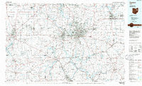
~ Canton OH topo map, 1:100000 scale, 30 X 60 Minute, Historical, 1986, updated 1986
Canton, Ohio, USGS topographic map dated 1986.
Includes geographic coordinates (latitude and longitude). This topographic map is suitable for hiking, camping, and exploring, or framing it as a wall map.
Printed on-demand using high resolution imagery, on heavy weight and acid free paper, or alternatively on a variety of synthetic materials.
Topos available on paper, Waterproof, Poly, or Tyvek. Usually shipping rolled, unless combined with other folded maps in one order.
- Product Number: USGS-5321466
- Free digital map download (high-resolution, GeoPDF): Canton, Ohio (file size: 17 MB)
- Map Size: please refer to the dimensions of the GeoPDF map above
- Weight (paper map): ca. 55 grams
- Map Type: POD USGS Topographic Map
- Map Series: HTMC
- Map Verison: Historical
- Cell ID: 76787
- Scan ID: 226363
- Imprint Year: 1986
- Aerial Photo Year: 1982
- Edit Year: 1986
- Datum: NAD27
- Map Projection: Universal Transverse Mercator
- Planimetric: Yes
- Map published by United States Geological Survey
- Map Language: English
- Scanner Resolution: 600 dpi
- Map Cell Name: Canton
- Grid size: 30 X 60 Minute
- Date on map: 1986
- Map Scale: 1:100000
- Geographical region: Ohio, United States
Neighboring Maps:
All neighboring USGS topo maps are available for sale online at a variety of scales.
Spatial coverage:
Topo map Canton, Ohio, covers the geographical area associated the following places:
- Skyline Hills - Piney View - Villages At Meadow Wood - Lynn Center Park - Hills Trailer Court - New Cumberland - Springhill - Spring Valley Estates - Raintree Estates - Lakeview Heights - Hametown - Lindale Heights - Evergreen Mobile Park - Cozy Acres - Lexington - Aultman - Lakeview - Carie Hill Estates - Edmeyer Park - West Manor Mobile Home Park - Beechtree Estates - Westview - Canal Fulton - Lakes Of Green - Alliance - Dundee - Charity Rotch - Rockwood Park - Homeworth - Westwood - Waterside - Pekin - Indianola Estates - Finley Homesites - Kungle Heights - Sweetbriar - Atwood Crossing - Tabor - New Harrisburg - Chenoweth Estates - Alliance Junction - Tarrymore - Harrisburg - Mishler - Ridge Mobile Home Park - Washington Hall - Crystal Park - Dutchtown - Minerva - Pine Hill - Winfield - North Industry - Deardoffs Mills (historical) - Sippo Heights - Paris - Sherwood (historical) - Richville - Charleston Place - Middlebranch - Whispering Oaks - Edgewood Park - Springview Estates - Ellis Estates - Smithville - West Canaan - Columbia - Navarre Village - Myersville - Fohl Village - Amherst Heights - Stanwood - Mount Marie Heights - Tower Terrace - Town And Country Park Estates - Greenfield Farms - Pattersonville - Solar Estates - Leavittsville - Douglas (historical) - Bon Air Estates - Pleasant Hills Estates - West Manor - Cutty Sunset Mobile Home Park - Indian Head Village - Louisville - Zoar - Fox Run Meadows - Hartville - Greentown - Forest Creek - Smithville Trailer Park - Holmesville - Waterloo - Charm - Art Smith Trailer Park - Green Highlands - Dalton - M And C Mobile Village - Withering Heights - Hyde Park
- Map Area ID: AREA4140.5-82-81
- Northwest corner Lat/Long code: USGSNW41-82
- Northeast corner Lat/Long code: USGSNE41-81
- Southwest corner Lat/Long code: USGSSW40.5-82
- Southeast corner Lat/Long code: USGSSE40.5-81
- Northern map edge Latitude: 41
- Southern map edge Latitude: 40.5
- Western map edge Longitude: -82
- Eastern map edge Longitude: -81


