
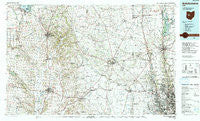
~ Bellefontaine OH topo map, 1:100000 scale, 30 X 60 Minute, Historical, 1992, updated 1992
Bellefontaine, Ohio, USGS topographic map dated 1992.
Includes geographic coordinates (latitude and longitude). This topographic map is suitable for hiking, camping, and exploring, or framing it as a wall map.
Printed on-demand using high resolution imagery, on heavy weight and acid free paper, or alternatively on a variety of synthetic materials.
Topos available on paper, Waterproof, Poly, or Tyvek. Usually shipping rolled, unless combined with other folded maps in one order.
- Product Number: USGS-5321464
- Free digital map download (high-resolution, GeoPDF): Bellefontaine, Ohio (file size: 23 MB)
- Map Size: please refer to the dimensions of the GeoPDF map above
- Weight (paper map): ca. 55 grams
- Map Type: POD USGS Topographic Map
- Map Series: HTMC
- Map Verison: Historical
- Cell ID: 67123
- Scan ID: 226288
- Imprint Year: 1992
- Woodland Tint: Yes
- Aerial Photo Year: 1989
- Edit Year: 1992
- Datum: NAD27
- Map Projection: Universal Transverse Mercator
- Map published by United States Geological Survey
- Map Language: English
- Scanner Resolution: 600 dpi
- Map Cell Name: Bellefontaine
- Grid size: 30 X 60 Minute
- Date on map: 1992
- Map Scale: 1:100000
- Geographical region: Ohio, United States
Neighboring Maps:
All neighboring USGS topo maps are available for sale online at a variety of scales.
Spatial coverage:
Topo map Bellefontaine, Ohio, covers the geographical area associated the following places:
- Resaca - Carriage Run - Hillcrest Mobile Home Park - Lakes Edge Mobile Park - Paget - Bethlehem (historical) - Plumwood - Avery Estates - Carriage Acres - Carson Farms - Kensington Place - Orchard Island - Iron City - Walnut Grove - Shelbourne Forest - Newmans - Nottingham - Mar-nel Mobile Home Park - West Jackson - New Richland - Braumiller Woods - Olentangy High Bluffs - The Groves At Newmans Crossing - Plateau Acres - Fleetwood Park - Chuckery - Nelson Farms - Milford Estates - Lynn - Abbey Chase - Wingate Farms - Richwood - Olentangy - Rathbone - Pharisburg - McKeever Mobile Home Park - Kingscreek - Stratford Woods - Rosedale - Sunnyview Farms - Carrington Place - Frost Mobile Home Park - Olentangy Meadows - Woodstock - Essex - Pluggys Town (historical) - Watkins - Lakeview Meadows - Olentangy Crossings - Windy Corner - Delaware Mobile Home Park - Wayside Mobile Home Park - Village At North Falls - Centerville - Glen Oak - Heather Ridge - Rushsylvania - Mumper Estates - Darby Glen - Lakeview - Crayon - Millbrook - Troyer Mobile Home Park - Arbela - Countryside Mobile Home Park - Dipple - Highway (historical) - Northville - Coventry Manor - Jerome - Waldo - Flint - Owl Town (historical) - Buxton Meadows - Olentangy Glade - Scioto Village - Northwoods - Silver Springs - Westwind - Terre Haute - Hayden - Amity - Brindle Corner - Kennard - Brookfield - Mill Creek Estates - Pottersburg - Harvest Square Mobile Home Park - Mount Tabor (historical) - Irwin - Adalee Park - Westbriar - Norton - Sandy Corners - White Sulphur - Gretna - The Suburbans Mobile Home Park - Meadows At Carson Farms - Santa Fe - Urbana
- Map Area ID: AREA40.540-84-83
- Northwest corner Lat/Long code: USGSNW40.5-84
- Northeast corner Lat/Long code: USGSNE40.5-83
- Southwest corner Lat/Long code: USGSSW40-84
- Southeast corner Lat/Long code: USGSSE40-83
- Northern map edge Latitude: 40.5
- Southern map edge Latitude: 40
- Western map edge Longitude: -84
- Eastern map edge Longitude: -83


