
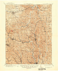
~ New Lexington OH topo map, 1:62500 scale, 15 X 15 Minute, Historical, 1911, updated 1948
New Lexington, Ohio, USGS topographic map dated 1911.
Includes geographic coordinates (latitude and longitude). This topographic map is suitable for hiking, camping, and exploring, or framing it as a wall map.
Printed on-demand using high resolution imagery, on heavy weight and acid free paper, or alternatively on a variety of synthetic materials.
Topos available on paper, Waterproof, Poly, or Tyvek. Usually shipping rolled, unless combined with other folded maps in one order.
- Product Number: USGS-5321144
- Free digital map download (high-resolution, GeoPDF): New Lexington, Ohio (file size: 11 MB)
- Map Size: please refer to the dimensions of the GeoPDF map above
- Weight (paper map): ca. 55 grams
- Map Type: POD USGS Topographic Map
- Map Series: HTMC
- Map Verison: Historical
- Cell ID: 58371
- Scan ID: 227633
- Imprint Year: 1948
- Survey Year: 1908
- Datum: NAD
- Map Projection: Polyconic
- Map published by United States Geological Survey
- Map Language: English
- Scanner Resolution: 600 dpi
- Map Cell Name: New Lexington
- Grid size: 15 X 15 Minute
- Date on map: 1911
- Map Scale: 1:62500
- Geographical region: Ohio, United States
Neighboring Maps:
All neighboring USGS topo maps are available for sale online at a variety of scales.
Spatial coverage:
Topo map New Lexington, Ohio, covers the geographical area associated the following places:
- Consol (historical) - Milligan - San Toy - Oakdale - Deavertown - Rehoboth - Hartleyville - McLuney - Hoboken (historical) - Hemlock - Whipstown - Buckingham - Rose Farm - Claybank (historical) - Mainsville - Yellowtown - Hunterdon - Sulphur Springs - New Pittsburg - Carbon Hill - Corning - Bristol - Moores Junction - Vicksville - Shawnee - Straitsville - Rendville - Bishopville - Lost Run (historical) - Glouster - Drakes - Hatfield - Wilbren - Hollister - Murray City - Ludington - Carrington - New Lexington - McLeish - Coalgate - Congo - Sand Run - McCuneville - Moxahala - Oakfield - New Town - Misco - Burr Oak - Flatiron - Alabama Hill - Palos - Millertown - Dicksonton (historical) - Tropic - Hamburg (historical) - Greeleyville - Chapel Hill - Sayre - Portersville - Dixie - Jobs - Lyonsdale (historical) - Stringtown - Oconorville (historical) - Blatchford - New Straitsville
- Map Area ID: AREA39.7539.5-82.25-82
- Northwest corner Lat/Long code: USGSNW39.75-82.25
- Northeast corner Lat/Long code: USGSNE39.75-82
- Southwest corner Lat/Long code: USGSSW39.5-82.25
- Southeast corner Lat/Long code: USGSSE39.5-82
- Northern map edge Latitude: 39.75
- Southern map edge Latitude: 39.5
- Western map edge Longitude: -82.25
- Eastern map edge Longitude: -82


